If you’re planning a Haeinsa Temple to Sangwangbong Peak hike, you’re in for one of the most rewarding day hikes in southern Korea. Rising to 1,430 meters above sea level, Sangwangbong Peak is the crown of Gayasan National Park — and the trail from Haeinsa is the classic way to reach it. Whether you’re a seasoned hiker or a confident beginner, this guide covers before you lace up your boots.
Contents
Quick Facts
| Altitude | 1,430m (Sangwangbong Peak) |
|---|---|
| Distance | 4.8km to 5.2km one-way (Approx. 10km round-trip from the Parking Lot/Visitor Center) |
| Duration | 2.5 to 3 hours one-way (5 to 6 hours round-trip) |
| Difficulty | Moderate (보통) |
| Trailhead | 해인사 탐방지원센터 (Haeinsa Trailhead Information Center) |
| Transport | Direct bus from Daegu Seobu Bus Terminal (대구서부정류장) to Haeinsa. Check Naver Map for current bus numbers and schedules. |
| Entrance Fee | Free |
| Seasonal Closures | Spring: February 1 – May 15 / Autumn: November 1 – December 15 for fire prevention. Check KNPS for exact dates. |
Getting to Haeinsa Trailhead
Getting to Haeinsa from a major city is straightforward — the most common approach for visitors is to head to Daegu Seobu Bus Terminal (대구서부정류장), where you can catch a direct bus to Haeinsa. Bus schedules and numbers do change seasonally, so I recommend checking current timetables on Naver Map before you travel.
One important heads-up for international visitors: Google Maps is notoriously unreliable in Korea for public transit and rural routes. Instead, use Naver Map or KakaoMap — both work excellently and have English-language options. To navigate to the trailhead, copy and paste this Korean text directly into your map app of choice:
해인사 탐방지원센터
That’s the official name of the Haeinsa Trailhead Information Center, and it’ll pin you to exactly the right starting point. Taxis from nearby towns are also an option — just show the driver that Korean text and you’ll be set.
Before you leave the nearest town or shop, stock up on everything you’ll need for the trail. There are no shops, vending machines, or food stalls on the hiking trail itself past the Haeinsa Trailhead Information Center. There are, however, restaurants and small shops in the village area near Haeinsa Temple and the bus stop, so make use of those before you reach the trailhead. Grab water, snacks, and any energy bars you need at a local shop or restaurant near the bus stop. These are your best friend before a Korean mountain hike.
Trail Guide: Haeinsa to Sangwangbong Peak
The route from the Haeinsa Trailhead Information Center (해인사 탐방지원센터) to Sangwangbong Peak covers 4.0km one-way, making it an 8.0km round-trip in total. The Korea National Park Service (KNPS) officially rates this trail as Moderate (보통) in difficulty — it’s a genuine mountain hike that demands a reasonable level of fitness, but it’s well within reach for most active travellers.
Plan to spend approximately 2 hours on the ascent and budget a similar amount of time for the descent, giving you a total round-trip time of around 4 hours. Of course, your actual pace will depend on your fitness level, how often you stop to rest, and the conditions on the day — so treat those figures as a solid baseline rather than a strict schedule.
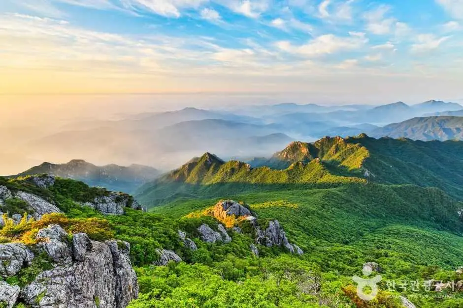
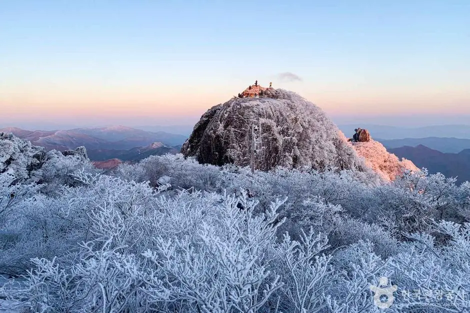
At the summit, Sangwangbong Peak stands at 1,430 meters above sea level, the highest point in all of Gayasan National Park. Reaching the top is a genuine achievement, and the elevation means you should be prepared for cooler temperatures and potentially stronger winds at the peak compared to the trailhead, even on warm days.
For the most up-to-date trail information, including any temporary closures or route changes, check the Official Gayasan National Park Trail Information before your visit.
Practical Tips for Hiking Gayasan
A few practical points that’ll make your hike safer and more enjoyable:
- Start early. I’d suggest arriving at the trailhead as early as possible, this gives you a comfortable buffer for the round trip, avoids the midday heat in summer, and means you’ll have the best light at the summit.
- Bring enough water. There are no water fountains on the trail. Carry more than you think you’ll need for a hike of this length and elevation gain.
- Pack your snacks before the trailhead. As mentioned, there are zero commercial facilities on the hiking trail itself past the Haeinsa Trailhead Information Center. Stock up at a local shop or restaurant before you arrive.
- Take all your trash back down. Korean national park trails have no rubbish bins. This is standard practice across all Korean mountains, pack a small bag to carry your waste out with you.
- Dress in layers. Temperatures at 1,430 meters can be significantly cooler than at the base, and weather in the mountains can shift quickly. A lightweight windproof layer is always worth carrying.
- Wear proper footwear. Trail shoes or hiking boots with good grip are strongly recommended. Sandals or flat sneakers aren’t appropriate for a mountain trail of this rating.
- Check the weather forecast. Mountain weather can change rapidly. Check the forecast for the Gayasan area before you set out.
- Entrance is free. National Park and cultural heritage site entrance fees across Korea were abolished in May 2023, so there’s no ticket to buy at the gate.
Seasonal Closures to Know Before You Go
This is one of the most important things to check before planning your trip. Gayasan National Park, like most Korean national parks, implements seasonal trail closures for fire prevention. These typically fall during two periods:
- Spring closure: Approximately February 15 to May 15
- Autumn closure: Approximately November 15 to December 15
During these windows, access to certain trails, potentially including the route to Sangwangbong Peak, may be restricted or completely closed. The exact dates can shift from year to year, so always verify the current closure schedule on the official KNPS website before you travel. Turning up to a closed trailhead is a frustrating experience that’s entirely avoidable with a quick check in advance.
In practical terms, this means the best windows for this hike are typically late May through mid-November, with summer and early autumn being particularly popular seasons. If you’re visiting during the closure periods, use Naver Map or KakaoMap to search for alternative open trails within the park.
Final Thoughts
The Haeinsa Temple to Sangwangbong Peak hike is a satisfying mountain experience, a moderate, well-defined trail leading to the highest summit in Gayasan National Park, all starting from one of Korea’s most historically significant temple complexes. At 8.0km round-trip with a 4-hour total time estimate, it’s a full but very manageable day out for active travellers.
before you go:
- Use Naver Map or KakaoMap, not Google Maps, and search for 해인사 탐방지원센터
- Take the direct intercity bus from Seobu Intercity Bus Terminal (서부시외버스터미널/서부정류장) or Bus No. 806 (for local stops).
- Buy all your water and snacks at a local shop or restaurant before reaching the trailhead
- Carry all your rubbish back down, no bins on the trail
- Check for seasonal fire prevention closures on the KNPS website before your visit
- Entrance to the national park is completely free
Gayasan is one of those parks that rewards hikers who come prepared, and with the right planning, this route to Sangwangbong Peak is an experience you’ll be talking about long after you’ve come back down the mountain.
Have you hiked in Gayasan National Park before, or is this on your Korea bucket list? Drop a comment below. I’d love to know which season you’re planning to visit and whether you’ve any questions about the trail!
* Cover image source: ⓒ한국관광공사 포토코리아-김범용