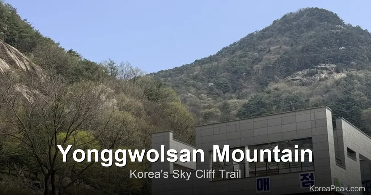
Yonggwolsan Sky Trail Hiking Korea: The Ultimate Guide to Sunchang’s Cliff Boardwalk
If Yonggwolsan Sky Trail hiking Korea is on your bucket list — or if you’ve never heard of it yet but love dramatic scenery — this guide will convince you to make the trip. Tucked into the hills of Sunchang County in Jeollabuk-do (North Jeolla Province), Yonggwolsan (용궐산) is home to one of Korea’s most visually arresting cliff-side boardwalk experiences: the 하늘길 Hanuel-gil Sky Trail Course. With 1,300 wooden deck stairs bolted directly into towering rock faces and sweeping views of the serpentine Seomjingang River (섬진강) below, it’s easy to see why locals have nicknamed this place Korea’s Zhangjiajie. From Seoul, the journey takes roughly 2.5 to 3 hours by express bus — making it a very achievable weekend escape.
Contents
- Trail Overview & Quick Facts
- Getting There & Navigation
- Parking Tips
- On-Site Facilities & What to Bring
- Entrance Fee & Voucher Perk
- Starting the Sky Trail: Trailhead to the Boardwalk
- The Jandogil (잔도길): Walking the Cliff-Side Boardwalk
- Chinese-Style Rock Carvings on the Cliff Face
- Biryongjeong Pavilion: The Highest Point
- Panoramic Seomjingang River Views
- Seomjingang Riverside Access Below the Parking Lot
- Family-Friendly Hiking on the Sky Trail
- Korean Hiking Pro-Tips for First-Timers
- Post-Hike BBQ: Malttonguri Makchang in Imsil
- What Is Makchang? A Guide to Korean Pork Offal BBQ
- Navigation & Naver Map Search Keywords
- Final Thoughts & Call to Action
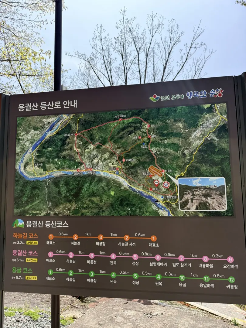
Trail Overview & Quick Facts
- Mountain: 용궐산 (Yonggwolsan Mountain), Sunchang County, Jeollabuk-do Special Self-Governing Province
- Trail Name: 하늘길 코스 — Hanuel-gil Sky Trail Course
- Difficulty: Moderate
- Duration: Approximately 2 hours
- Trailhead: Yonggwolsan Natural Recreation Forest Parking Lot (용궐산 자연휴양림 주차장) — Address: 전북특별자치도 순창군 동계면 장군목길 564
- Key Feature: Cliff-side boardwalk (잔도길 Jandogil) with 1,300 deck stairs along massive rock faces
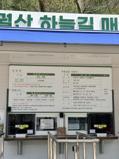
- Entrance Fee: 4,000 KRW per person (adults & students)
- Operating Hours: 09:00–17:00 (March–November) / 09:00–16:00 (December–February)
- Distance from Seoul: Approx. 2.5–3 hours by express bus
The Sky Trail is classified as moderate difficulty, which in practical terms means sustained stair-climbing on well-maintained wooden deck and stone stairways rather than technical scrambling. The 1,300-step boardwalk is the defining challenge — it demands cardiovascular effort but remains fully accessible to reasonably fit hikers of most ages.
Getting There & Navigation
Getting to Yonggwolsan is straightforward if you’re travelling by car, but requires a little planning if you’re relying on public transport.
By Car: Enter 용궐산 자연휴양림 (Yonggwolsan Natural Recreation Forest) into any Korean GPS app — KakaoMap or Naver Map work best, as Google Maps coverage in rural Korea can be unreliable. One important caution: the final access road running alongside the Seomjingang River is narrow with no lane markings and is used for two-way traffic. Drive slowly and be prepared to pull to the side to pass oncoming vehicles. Inexperienced drivers should take their time on this stretch.
From Seoul by Public Transport: Take an express bus from Seoul Nambu Terminal (남부터미널) or Seoul Central City Terminal (센트럴시티) to Sunchang (순창) — journey time is approximately 2.5 to 3 hours. From Sunchang Bus Terminal (순창버스터미널), buses to the Donggyemyeon (동계면) area do exist but run infrequently. A taxi from Sunchang town (approximately 20 minutes) is the most practical option for the final stretch. Alternatively, renting a car at Jeonju (전주) — a larger nearby city with better transport links — is a convenient option worth considering.
Parking Tips
The parking lot at Yonggwolsan Natural Recreation Forest is the starting point for everything. Based on weekend observations, the lot runs at approximately half capacity around noon, so finding a space is generally manageable — but arriving earlier is always advisable on warm-weather weekends.
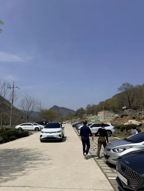
Here is one genuinely useful piece of parking advice: park further inside the lot, closer to the ticketing office (매표소), rather than near the entrance. The spots nearest to the entrance are actually the farthest from the ticket booth and trailhead. The on-site snack shop (매점), however, is located closer to the entrance-side of the parking area — so if you need to stock up on water before heading to the booth, stop there first, then drive or walk deeper into the lot.
On-Site Facilities & What to Bring
Yonggwolsan Natural Recreation Forest is well-equipped for a day hike. Here’s what you can expect on-site:

- Toilets: Available at the trailhead, near the ticketing office and parking area.
- Snack Shop (매점): Located near the parking lot entrance. Sells water, sports drinks (including Gatorade), and snacks. This is your last chance to buy water before the trail — there are no water sources on the route itself.
- Shoe & Clothing Dust Blower (흙먼지 털이기): Available at the trailhead. This is a standard piece of equipment at major Korean hiking destinations — a compressed air blower you use after the hike to clean dust and dirt off your shoes and clothing before getting back in your car.
- Convenience Store: There is no confirmed CU or GS25 (Korea’s ubiquitous convenience store chains) on-site. The nearest stores are likely in Sunchang town center, approximately 20 minutes away. Bring at least 1 litre of water per person from home or purchase at the snack shop before you start.
Entrance Fee & Voucher Perk
Entry to the Sky Trail costs 4,000 KRW per person for both adults and students. Operating hours are 09:00 to 17:00 from March through November, and 09:00 to 16:00 from December through February — plan your arrival time accordingly, especially in winter when the window is shorter.
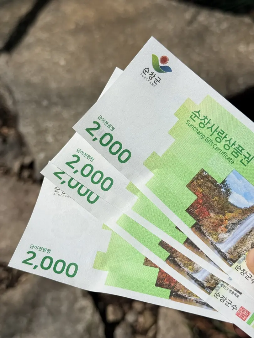
There’s a notable perk built into the ticket price: every ticket includes a 2,000 KRW Sunchang Love Gift Voucher (순창사랑상품권) per person. This is a local merchant voucher redeemable at participating shops in Sunchang. In effect, you’re getting half your entrance fee back as spending credit in the local economy — a nice touch that encourages visitors to explore the town. Keep the voucher handy and look for participating shops when you’re in the Sunchang area.
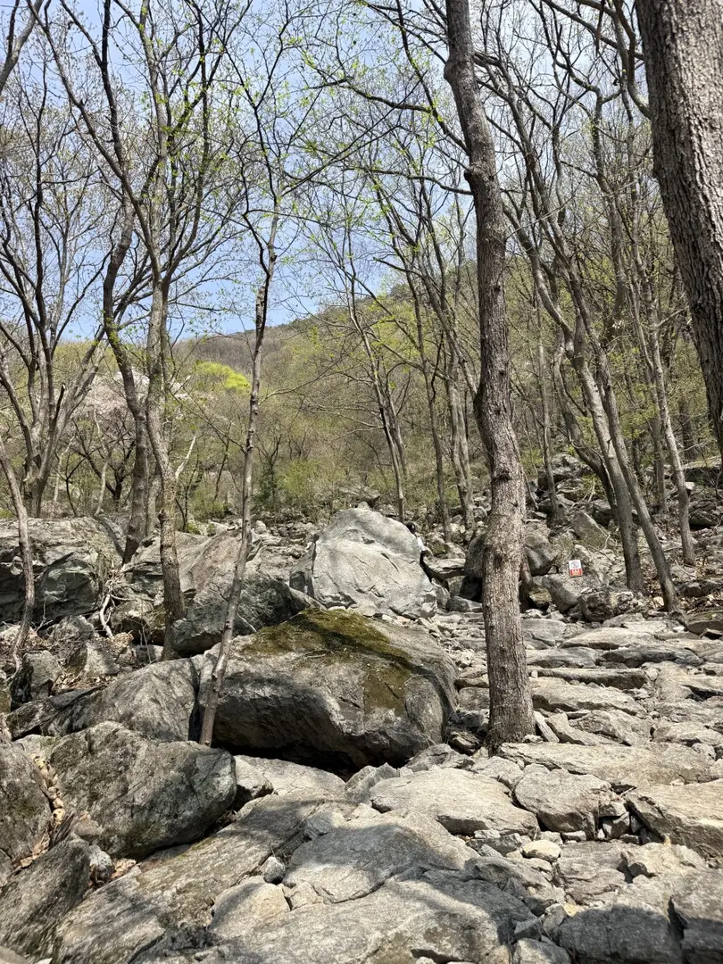
Starting the Sky Trail: Trailhead to the Boardwalk
After purchasing your ticket at the 매표소 (ticketing office), the trail begins in earnest. The initial section is composed of well-maintained stone stairways that lead you upward through the forested hillside toward the base of the main cliff face. The path is clearly marked and the surface underfoot is consistently solid — no loose scree or technical sections to navigate.
The gradient increases as you approach the cliff, and it’s here that you begin to appreciate the scale of the rock faces that define Yonggwolsan’s character. The transition from forest path to open boardwalk is one of the trail’s most memorable moments — the landscape opens up suddenly, and the Seomjingang River valley spreads out below.
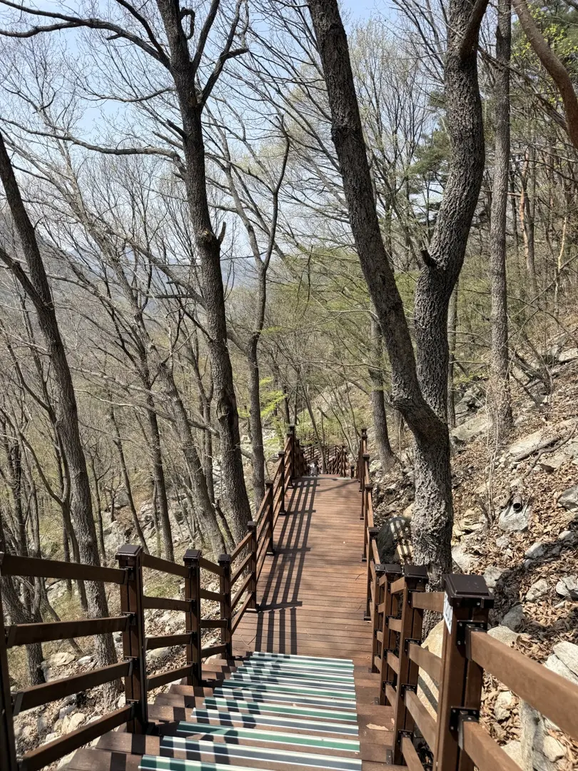
The Jandogil (잔도길): Walking the Cliff-Side Boardwalk
The 잔도길 (Jandogil) is the heart of the Yonggwolsan Sky Trail experience. The word jando (잔도) refers to a traditional style of cliff-side plank road — a walkway built directly onto a sheer rock face, historically used in mountainous regions of East Asia to traverse otherwise impassable terrain. At Yonggwolsan, this ancient concept has been realised as a modern wooden deck boardwalk with 1,300 individual stairs bolted and anchored into the surface of massive granite cliff faces.
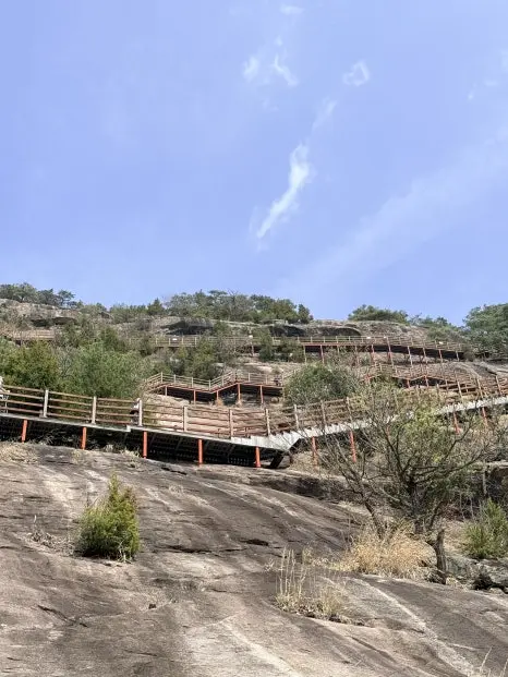
Walking the Jandogil is an immersive experience. The wooden boards are solidly constructed and the railings are secure, but the exposure — the sense of open air and the drop below — gives the route a genuine sense of adventure. The stairways ascend and traverse the rock face in a series of switchbacks and straight climbs, with the cliff wall rising on one side and unobstructed views of the Seomjingang River valley opening on the other. This combination of enclosed rock and open panorama is what earns the trail its reputation.
Chinese-Style Rock Carvings on the Cliff Face
One of the more unusual highlights of the Sky Trail is the presence of Chinese-style rock carvings (한자 암각) carved directly into the cliff surface alongside the boardwalk. These carved Chinese characters — hanja (한자), the traditional script historically used in Korean writing — are etched into the living rock of the cliff face and represent a layer of cultural and historical interest that complements the natural drama of the landscape.
It is partly these dramatic carved rock faces, combined with the sheer scale of the cliff scenery and the elevated boardwalk, that have led visitors and media to dub Yonggwolsan Korea’s Zhangjiajie — a reference to the famous pillar rock formations in Hunan Province, China, made internationally famous by the film Avatar. While the geological profiles differ, the spirit of the comparison — vertiginous rock, sky-high walkways, forested valley below — is easy to appreciate in person.
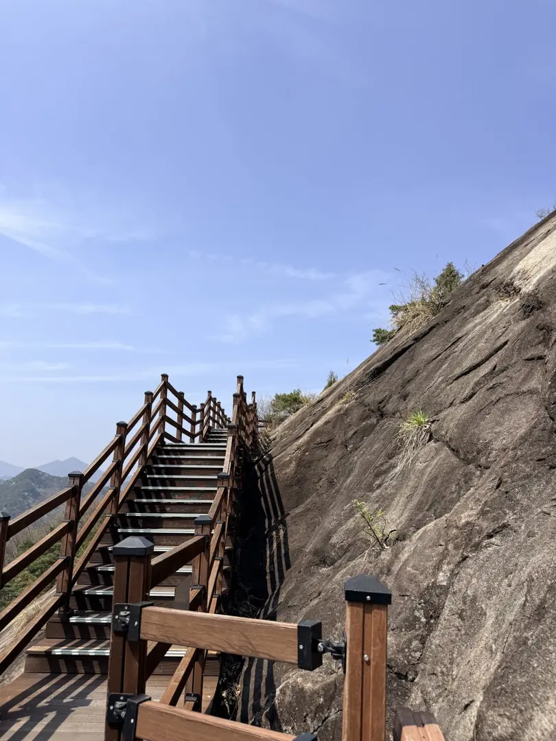
Biryongjeong Pavilion: The Highest Point
The 비룡정 (Biryongjeong Pavilion) marks the highest point of the Sky Trail Course. This traditional Korean-style wooden pavilion serves as both a rest stop and a viewing platform, and reaching it represents a natural milestone — the point at which the hardest climbing is behind you and the full reward of the trail opens up.
Biryongjeong is an ideal spot to pause, catch your breath, and take in the surroundings without the pressure of still having stairs to climb. The pavilion’s elevated position offers a commanding vantage point over the route you’ve just ascended and the landscape beyond. On clear days, the view from here is the trail’s crowning moment.
Panoramic Seomjingang River Views
Throughout the Jandogil boardwalk section and especially from Biryongjeong Pavilion, the Seomjingang River (섬진강) is the dominant visual feature. The Seomjingang is one of Korea’s most celebrated rivers — a relatively clean, undeveloped waterway that winds through the mountains and valleys of Jeollabuk-do and South Jeolla Province before reaching the southern coast. From the elevated walkways of Yonggwolsan, you can see the river looping in wide, sinuous curves through the forested valley far below.
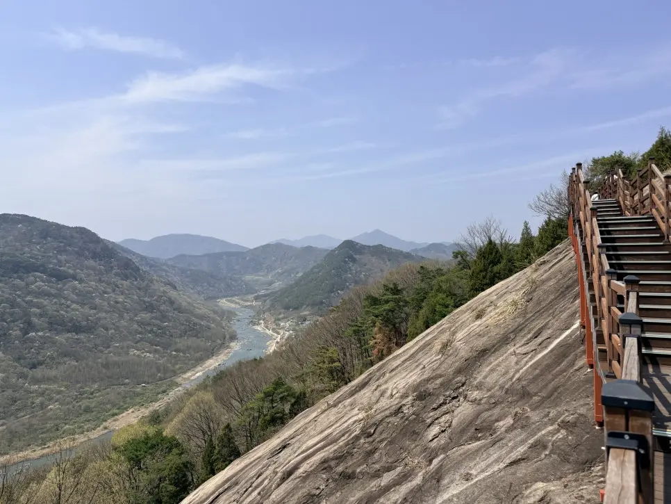
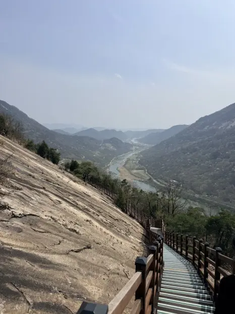
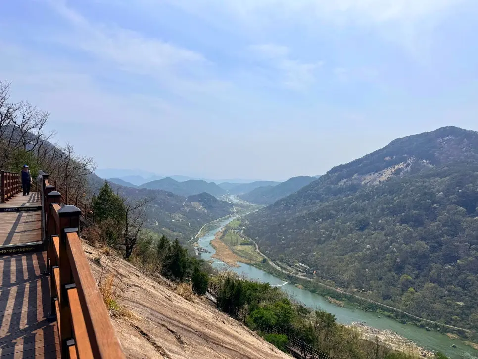
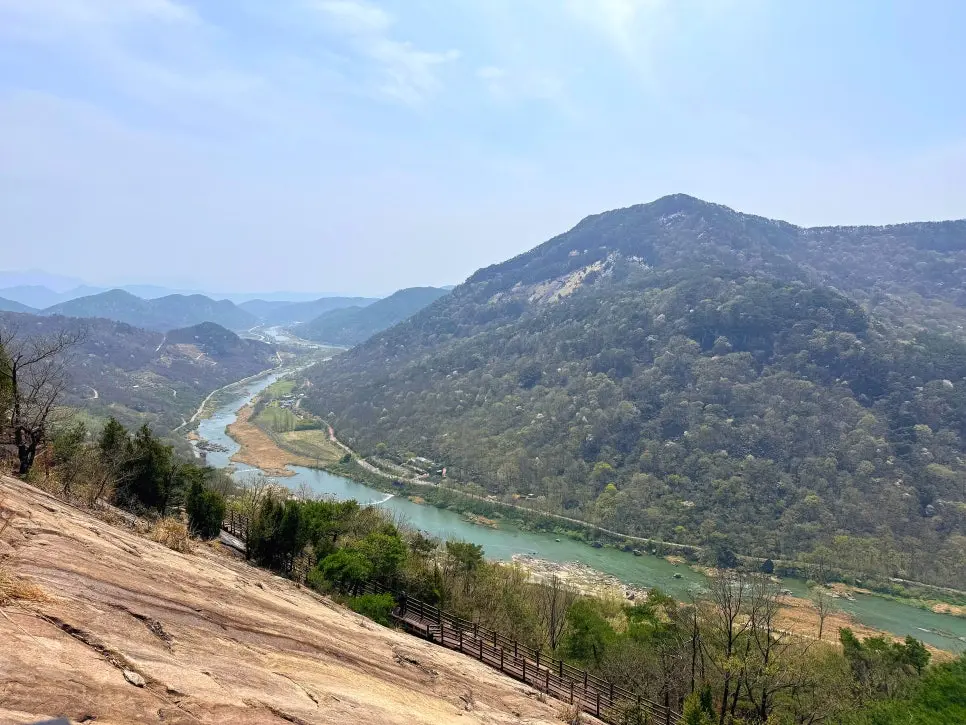
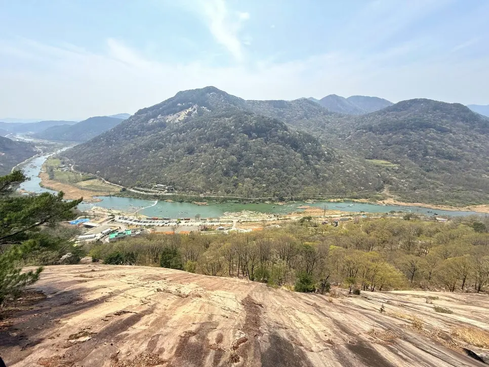
The combination of the river’s silver ribbon, the deep green of the surrounding forest, and the sheer cliff rock directly underfoot is what makes the Sky Trail photographs so compelling — and what makes the hike itself so much more than just a stair workout. These are genuinely panoramic views that reward the effort of the climb.
Seomjingang Riverside Access Below the Parking Lot
For those who want to extend the experience beyond the trail itself, the Seomjingang riverside is accessible just below the parking lot. This gives visitors the option of beginning or ending the day at the water’s edge — a pleasant contrast to the elevation and exposure of the cliff boardwalk. The riverside area near the Yonggwolsan trailhead is part of a section of the Seomjingang known for its natural character, and a short walk along the bank is a low-effort way to appreciate the river from a completely different perspective than the aerial views offered by the trail above.
Family-Friendly Hiking on the Sky Trail
One of Yonggwolsan Sky Trail’s practical strengths is its accessibility. The trail is suitable for families with children, and the well-maintained stone and deck stairways mean that the route never demands technical skill or off-trail navigation. The challenge is cumulative — 1,300 stairs is a real physical effort — but the surface is consistent and the handrails are in place throughout the exposed boardwalk sections.
The structured nature of the trail (clear start, clear end, fixed 2-hour duration) also makes it easy to plan around children’s energy levels and attention spans. The dramatic scenery — the cliff faces, the river views, the pavilion — provides natural points of interest and motivation along the way. For families seeking a genuinely scenic hike without the unpredictability of a wilderness trail, the Sky Trail is an excellent option.
Korean Hiking Pro-Tips for First-Timers
If this is your first time hiking in Korea, a few cultural and practical norms are worth knowing before you set out:
- Buy water and snacks before you arrive. Convenience stores (CU and GS25 are the two most common chains) are found throughout Korean towns and cities. Stock up before you leave town — as confirmed at Yonggwolsan, there is no convenience store on-site, and the on-trail snack shop has limited stock. Carry at least 1 litre of water per person.
- Pack out all your trash. Korean trail etiquette is strict on this point. There are typically no bins on the trail itself — everything you bring in, you carry out. This is a widely observed social norm, not just a rule on paper.
- Check for seasonal trail closures. Some Korean mountain trails are temporarily restricted or closed during spring and autumn fire prevention seasons (typically mid-February to mid-May and late October to late November, though exact dates vary by region and year). Always check the relevant local government or Korea Forest Service website before your visit — especially for trails passing through forested areas.
- Use Naver Map or KakaoMap for navigation. Google Maps works poorly in rural South Korea. Search in Korean script where possible for the most accurate results. Key search terms for Yonggwolsan are listed in the navigation section below.
- Respect operating hours. Many managed trails and recreation forests in Korea have strictly enforced entry cut-off times. Arriving close to the closing time listed above risks being turned away at the ticket booth.
- Hiking gear is taken seriously in Korea. Trekking poles, hiking boots, and moisture-wicking layers are standard even on moderate trails. You won’t be out of place in full hiking kit — in fact, you’ll fit right in.
For a broader overview of hiking culture and trail safety in Korea, the Korea Forest Service (산림청) website provides official information on national recreation forests, trail conditions, and seasonal closures.
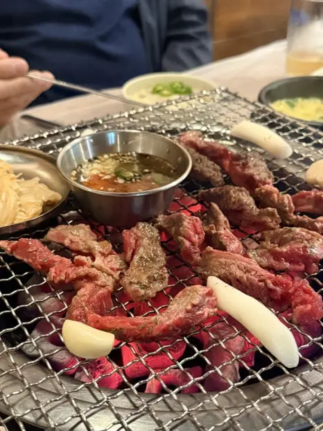
Post-Hike BBQ: Malttonguri Makchang in Imsil
After descending the Sky Trail, the post-hike meal is an experience in its own right. The recommended destination is 말똥구리 막창 (Malttonguri Makchang), a charcoal-grilled Korean BBQ restaurant located in Imsil town center (임실읍), approximately 30 to 40 minutes’ drive from the Yonggwolsan trailhead.


This is an extremely popular local spot — popular enough that it regularly fills up and gets fully booked by 6:00 PM. Reservations are strongly recommended, particularly on weekends. If you’re planning a full day trip that ends with dinner here, make the reservation before you leave home.
Address: 전북특별자치도 임실군 임실읍 중동로 38 — search 말똥구리 막창 임실 on Naver Map.
What Is Makchang? A Guide to Korean Pork Offal BBQ
For visitors unfamiliar with Korean BBQ vocabulary, makchang (막창) refers specifically to pork large intestine — a cut that is cleaned, prepared, and then grilled over charcoal at the table. It has a distinctive chewy texture and rich, slightly smoky flavour that pairs exceptionally well with the fermented and pickled accompaniments served alongside it.
At Malttonguri Makchang, the menu centres on charcoal-grilled pork offal BBQ, with the following key items available:
- 돼지막창 (Dwaeji Makchang / Pork Large Intestine): The signature dish — the namesake cut, grilled over charcoal.
- 삼겹살 (Samgyeopsal / Pork Belly): Korea’s most iconic BBQ cut — thick slices of pork belly grilled at the table. Widely familiar to international visitors.
- 소갈비살 (Sogalbigal / Beef Short Rib): Thinly sliced beef short rib, tender and flavourful when grilled.
- 뒷덜미살 (Dwitdeolmusal / Pork Neck): A lesser-known but prized cut from the back of the pork neck — marbled with fat and exceptionally juicy when grilled.
The meal is served with 멸젓 (Meljeot) — salted fermented anchovies used as a dipping condiment, intensely savoury and deeply traditional in Korean BBQ — and 백김치 (Baek-kimchi), which is white kimchi: kimchi made without the red chilli paste, resulting in a milder, crisp, lightly fermented cabbage side dish. Both are classic accompaniments that complement the richness of the grilled meats.
I strongly recommend building this meal into your itinerary. After two hours of stair-climbing on the cliff boardwalk, sitting down to charcoal-grilled BBQ in a lively local restaurant is a genuinely satisfying way to close the day.
Navigation & Naver Map Search Keywords
As noted above, Google Maps is not reliable for navigation in rural South Korea. Use Naver Map (네이버 지도) or KakaoMap (카카오맵) for all navigation on this trip. Both apps are free and available internationally. Copy and paste the Korean search terms below directly into the search bar for best results:
- Trailhead / Recreation Forest: 용궐산 자연휴양림
- Sky Trail (general search): 용궐산 하늘길
- Address search: 장군목길 564 순창
- Pavilion at highest point: 비룡정
- Post-hike restaurant: 말똥구리 막창 임실
- Broader trail search: 섬진강 잔도길
- Regional hiking search: 순창 등산 코스
- English search (Naver Maps accepts this): Yonggwolsan Natural Recreation Forest
For the drive to the trailhead, set your destination to 용궐산 자연휴양림 and follow the route carefully on the final narrow riverside road. Slow down well in advance of any bends where oncoming traffic may not be visible.
Final Thoughts
Yonggwolsan’s Hanuel-gil Sky Trail is one of those hikes that delivers on its reputation. The combination of the cliff-side Jandogil boardwalk, the 1,300 deck stairs rising against massive rock faces, the Chinese-character carvings in the stone, the Biryongjeong Pavilion at the top, and the sweeping panoramas of the Seomjingang River below adds up to a trail experience that is both physically engaging and visually extraordinary. At a moderate difficulty level and a two-hour duration, it is accessible enough to suit a wide range of hikers — families included — while remaining substantial enough to feel genuinely rewarding. The entrance fee is modest, the 2,000 KRW Sunchang Love Gift Voucher softens the cost further, and the post-hike charcoal BBQ at Malttonguri Makchang in Imsil is the kind of meal that turns a good day into a great one. Book the restaurant before you go, arrive at the trailhead well before the operating hours close, stock up on water at the on-site snack shop, and enjoy one of North Jeolla Province’s most spectacular half-day adventures.
Have you ever grilled makchang (돼지막창) or tried pork neck (뒷덜미살) at a Korean charcoal BBQ after a long hike? Or is there another post-hike meal in Korea that you swear by? Drop your recommendation in the comments below — I’d love to know what’s fuelling your adventures on the trail.