Gyeryongsan is the one hike outside Seoul where the KTX plus a short bus ride makes the total door-to-trailhead time under 2.5 hours. The Donghaksa Circular Course is a 10 km, approximately 6-hour Moderate-rated loop where the thing that actually carries the day is the Janyeonseongneung boardwalk ridge between Sambulbong and Gwaneumong (the latter is a Black Yak 100 stamp point for anyone collecting those). Below: KTX + bus routing, the route’s highlights in the order you’ll hit them, and the cherry-blossom timing I wish someone had told me.
Contents
Trail Overview & Quick Facts
- Trail Name: Donghaksa Circular Course (동학사 순환 코스)
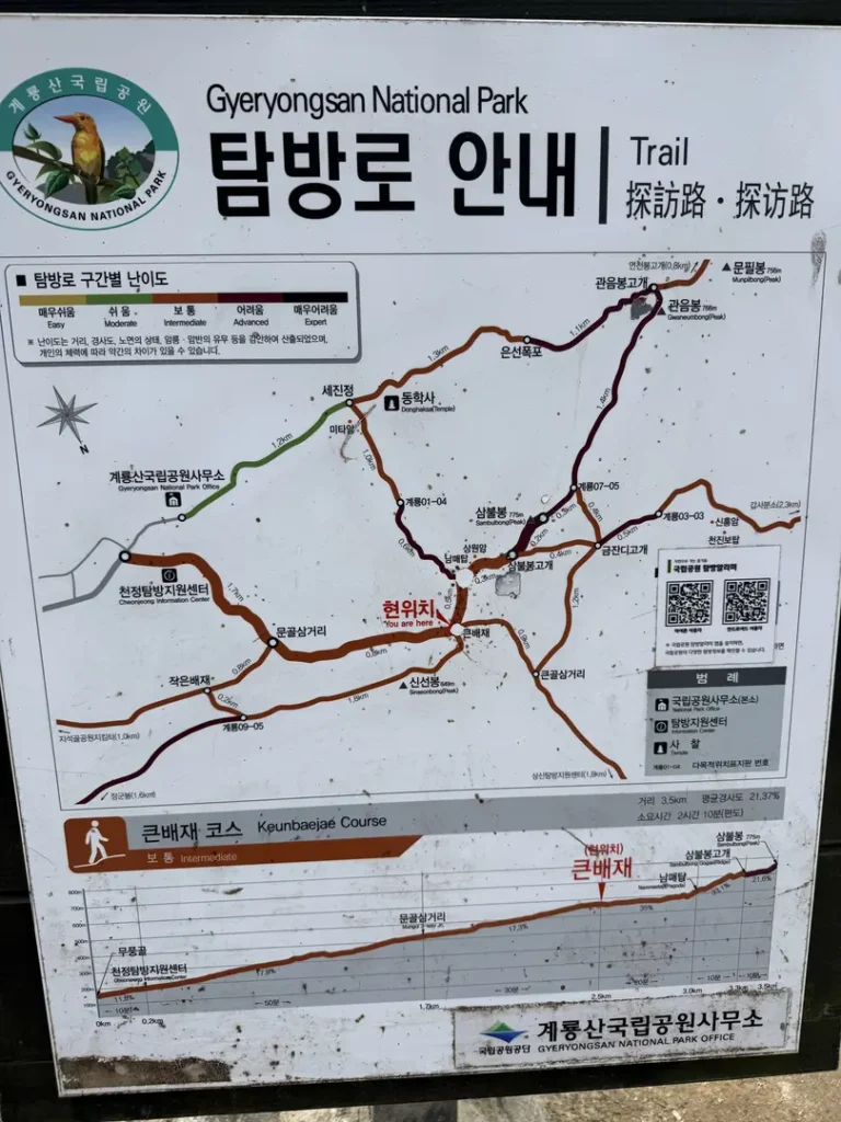
- Full Route: Cheonjeong Visitor Center → Nammae Pagoda → Sambulbong Peak → Janyeonseongneung Ridge → Gwaneumong Peak → Eunseon Waterfall → Donghaksa Temple → Parking Lot
- Total Distance: Approximately 10 km loop
- Duration: Approximately 6 hours
- Difficulty: Moderate
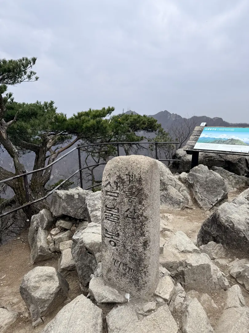
- Highest Point on This Route: Sambulbong Peak (삼불봉) at 775 m
- Trailhead: Donghaksa Parking Lot (동학사 주차장), Gyeryongsan National Park, South Chungcheong Province
- Parking Fee: Approx. ₩2,000–₩4,000 for small vehicles (paid at entry)
- Best Season: Spring (cherry blossoms, late March–early April) and autumn; trail is open year-round but check for seasonal fire-prevention closures
This loop is a classic for a reason. It offers genuine mountain terrain — steep staircases, exposed ridgeline, and rocky descents — while remaining accessible to hikers of moderate fitness. The circuit is designed so that the toughest climbing comes first and the descent through the temple valley feels like a reward.
Getting There & Navigation
By Train + Car Rental (Recommended from Seoul): Take a KTX or Mugunghwa express train from Seoul (Seoul Station or Yongsan Station) to Seo-Daejeon Station (서대전역), which takes approximately 1 to 1.5 hours. From Seo-Daejeon Station, you can rent a car through Socar — Korea’s popular app-based car-sharing service, similar to Zipcar — or through Kakao T. Drive time to the trailhead is approximately 1 hour during morning rush hour, and shorter outside peak times.
By Bus: If taking public transport, it’s recommended to arrive at Daejeon Station. From Daejeon Station, Bus No. 107 runs directly to the Donghaksa entrance.
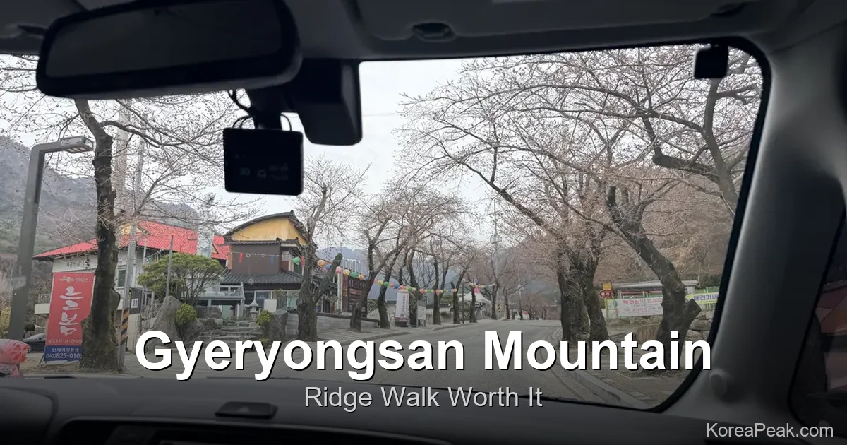
By Car: Drive directly to Donghaksa Parking Lot (동학사 주차장) inside Gyeryongsan National Park. Parking is prepaid at the entrance barrier. Fee is ₩4,000 for small-to-medium passenger vehicles and ₩2,000 for compact cars. Important: The parking lot fills up fast on weekends and especially during cherry blossom season in late March and early April. Aim to arrive by 8:00 a.m. on busy days.
Navigation Tip: Google Maps has limited accuracy for Korean trailheads and parking lots. Use Naver Map (네이버 지도) or KakaoMap instead. Copy and paste these Korean search terms directly into the app:
- 동학사 주차장 (Donghaksa Parking Lot)
- 천정탐방지원센터 (Cheonjeong Trail Support Center)
- 계룡산 동학사 코스 (Gyeryongsan Donghaksa Course)
Trailhead Facilities
The official starting point of the Donghaksa Circular Course is the Cheonjeong Trail Support Center (천정탐방지원센터), located a short walk from the parking lot. This visitor center provides printed trail maps and safety information — pick one up before you head out. Restrooms are available here and again near the Donghaksa Temple area at the end of the loop.
There are no resupply points once you’re on the ridge, so preparation is essential. Small snack stalls and souvenir vendors are typically found near the Donghaksa Temple entrance area. A convenience store, look for chains like CU or GS25, is more likely found in the nearby Donghak-dong village or close to the parking lot entrance; confirm availability on-site before relying on it. Stock up on water and snacks before entering the national park.
Cheonjeong Center to Nammae Pagoda
From the Cheonjeong Trail Support Center, the trail climbs steadily through forested terrain. The path is well-marked and wide in this opening section, making it a pleasant warm-up before the more technical terrain above. The gradient is consistent and manageable for most hikers of moderate fitness.
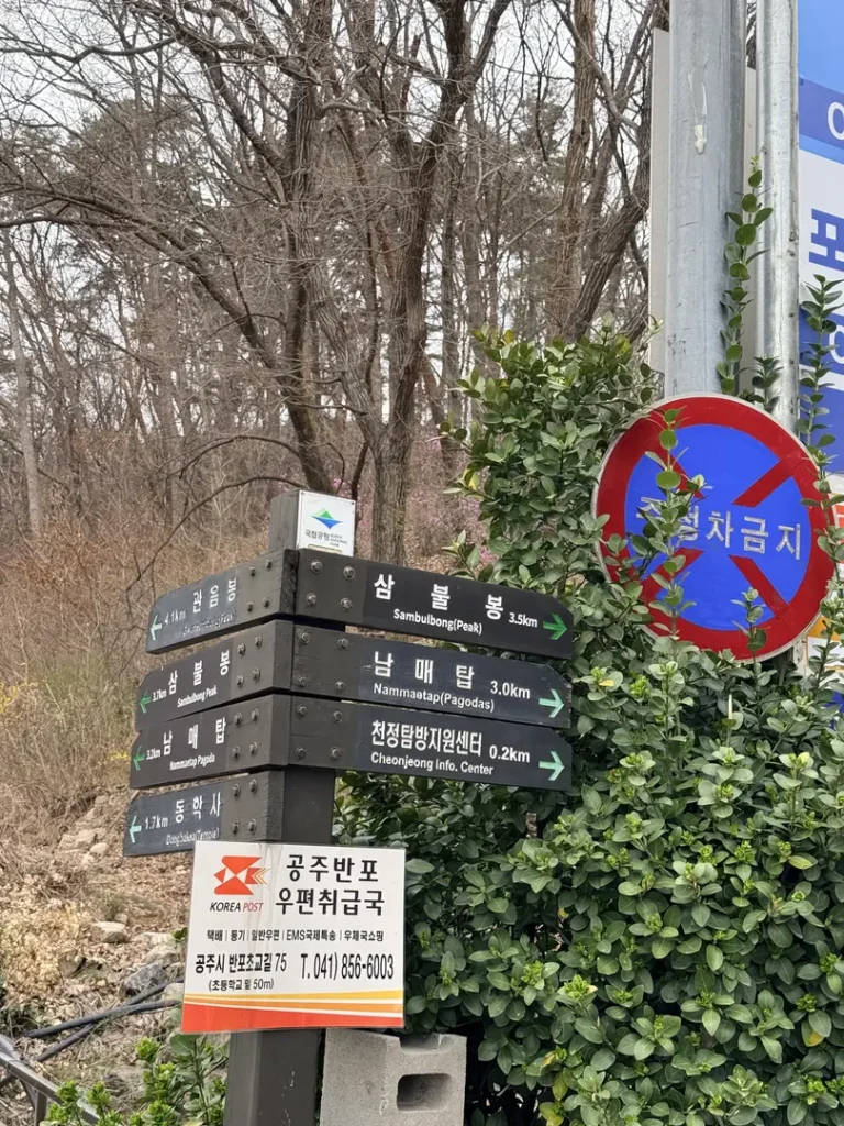
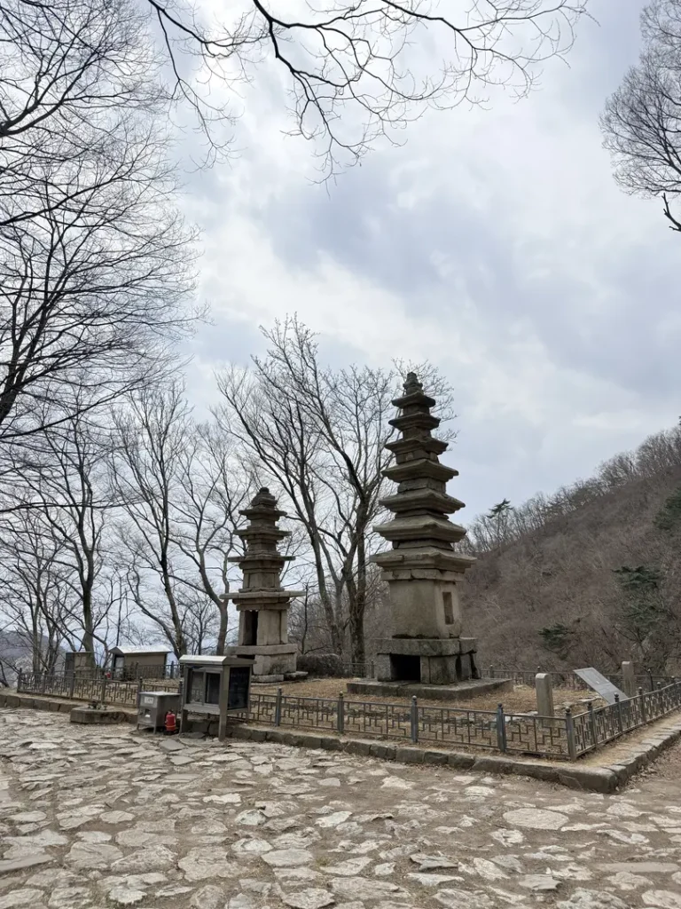
The first major landmark you reach is Nammae Pagoda (남매탑), a pair of historic twin stone pagodas set in a scenic clearing. “Nammae” (남매) means “brother and sister” in Korean, and the two pagodas are named accordingly, a detail that gives this spot a quiet, storytelling quality. For casual visitors or families, Nammae Pagoda serves as a popular turnaround point. For those continuing the full circuit, it marks the transition toward the steeper upper ridge.
Nammae Pagoda to Sambulbong Peak
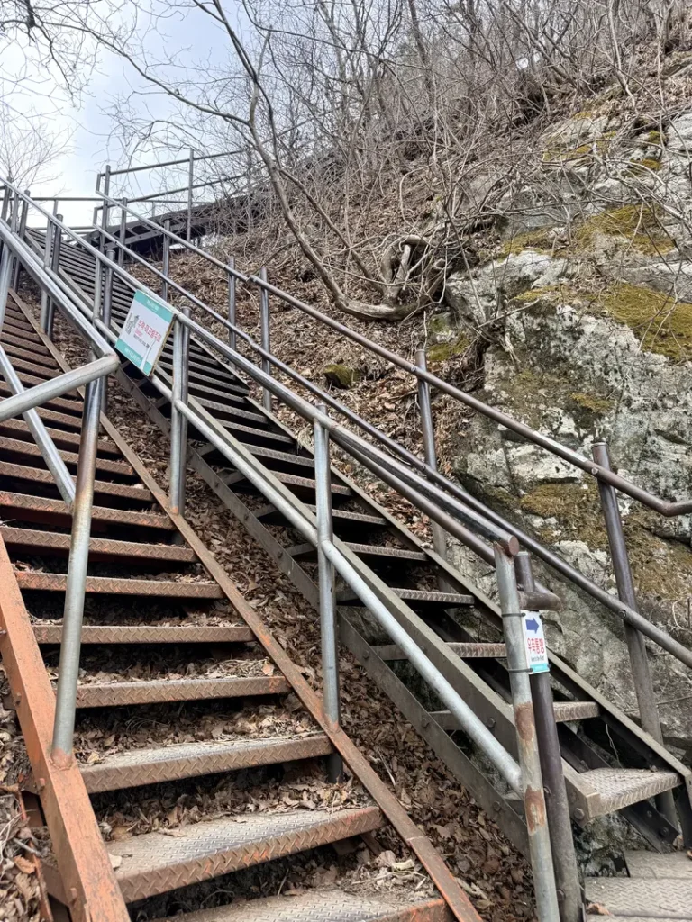
Above Nammae Pagoda, the trail steepens considerably as it pushes toward Sambulbong Peak (삼불봉, 775 m). Expect a steep staircase section equipped with metal handrails, these are useful and you’ll likely want to use them. The effort is rewarded at the summit, which is the highest point on this circuit.
From Sambulbong, hikers are treated to sweeping panoramic views of Cheonhwangbong (Gyeryongsan’s main summit) and Gwaneumong Peak ahead on the ridge. The terrain here’s rocky and exposed, giving a genuine “above the treeline” feeling despite the relatively modest elevation. This is a good spot to rest, eat a snack, and appreciate how much ground you’ve already covered.
Janyeonseongneung Ridge: The Highlight
The stretch between Sambulbong and Gwaneumong is the undisputed showstopper of the entire hike: the Janyeonseongneung Ridge (자연성릉). This approximately 1.8 km dramatic rocky ridgeline features rugged natural rock paths combined with steep metal staircases and safety decks in difficult sections, meaning the path is built on wooden platforms and staircases anchored to the rock face, an engineering feat that makes the exposure both safe and spectacular.
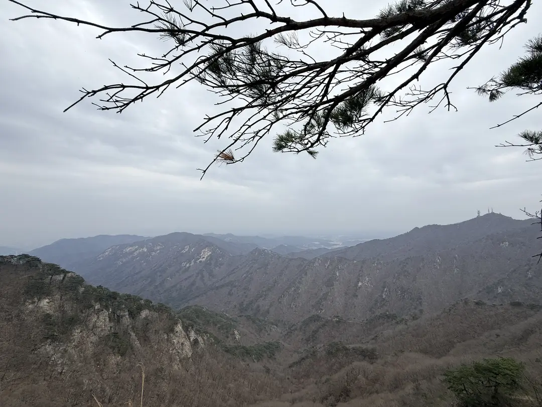
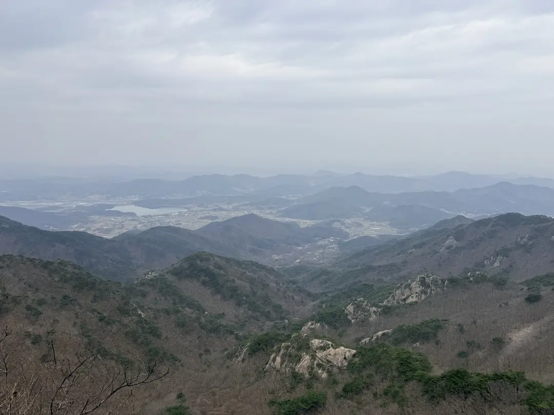
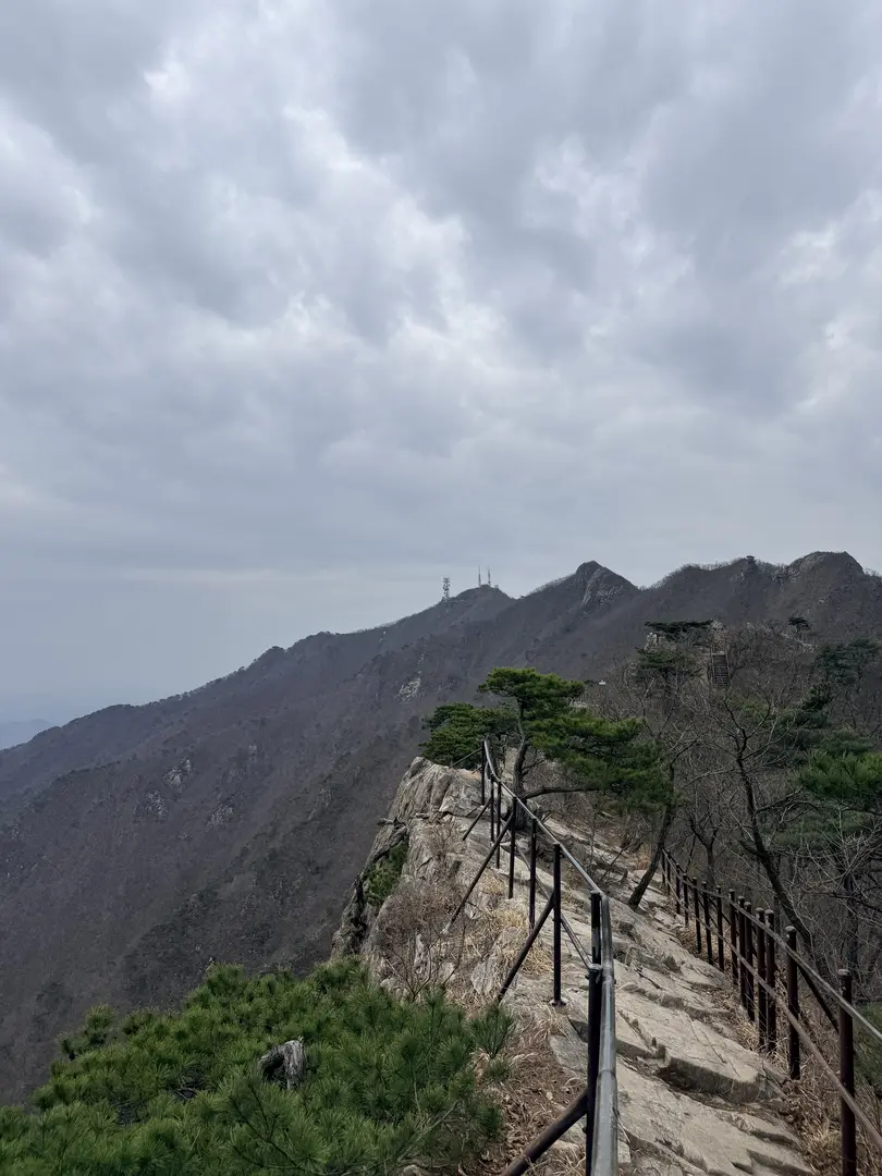
The boardwalk stairs are well-maintained but steep in places. The ridge offers the best panoramic views of the entire hike in both directions. On a clear day, the layered peaks of Gyeryongsan National Park stretch out on either side of you, with valleys far below. Take your time here, this is what you came for. The boardwalk also means that even in damp conditions, the footing is generally secure, though caution is still advised on wet days.
Gwaneumong Peak & Black Yak Certification
At the far end of the Janyeonseongneung Ridge, you arrive at Gwaneumong Peak (관음봉, 766 m), ten metres lower than Sambulbong but arguably more famous among serious Korean hikers. Gwaneumong is an official stamp and certification point for the Black Yak 100 Famous Mountains Challenge (블랙야크 100대 명산).
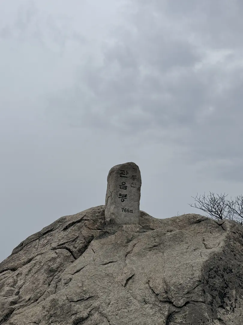
The Black Yak 100 Famous Mountains Challenge is a hugely popular hiking achievement program in Korea, run by the outdoor brand Black Yak. Hikers collect official stamps or digital certifications at designated peaks across 100 of Korea’s most celebrated mountains. Gyeryongsan, and specifically Gwaneumong, is one of those 100 peaks. If you’re participating in the challenge, bring your Black Yak app or passport to collect your stamp here. For more information on the challenge, visit the official Black Yak website.
Eunseon Waterfall
Descending from Gwaneumong toward Donghaksa Temple, the trail passes Eunseon Waterfall (은선폭포). The waterfall adds a scenic and tranquil pause to what has been an energetic descent. A practical note: water flow at Eunseon Waterfall is modest outside of the rainy season (the Korean monsoon, or jangma, typically runs June through July). If you’re hiking in spring or autumn, expect a gentle cascade rather than a dramatic torrent, it’s still a lovely spot, but manage expectations accordingly.
Donghaksa Temple
The final cultural landmark of the loop is Donghaksa Temple (동학사), a traditional Korean Buddhist temple situated in a forested valley near the trailhead. The temple complex is worth a brief, respectful visit. When entering any Korean Buddhist temple, dress modestly and speak quietly out of respect for worshippers.
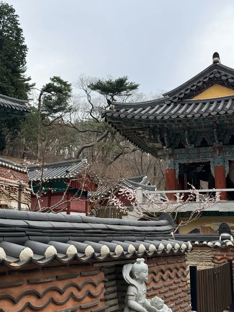
Donghaksa Temple is particularly renowned for its cherry blossom festival, typically held in late March to early April. The tree-lined path leading to the temple becomes one of the most photographed spots in South Chungcheong Province during this period. If you’re planning to visit during cherry blossom season, note that crowds and parking demand surge significantly, an early start is strongly advised. From the temple, it’s a short walk back to the parking lot to complete the loop.
Korean Hiking Pro-Tips
- Footwear: Proper hiking boots with ankle support and grip are strongly recommended. Rocky and leaf-covered descents on this trail can be very slippery, especially in autumn or after rain. Don’t attempt this trail in sneakers or sandals.
- Water and Snacks: There are no shops or vending machines on the ridge. Buy water and snacks at a convenience store. CU (씨유) or GS25 are common chains, before reaching the national park entrance.
- Pack Out Your Trash: Korea’s national parks operate a strict carry-in, carry-out policy. There are no trail-side rubbish bins. Bring a small bag for your litter and dispose of it at the trailhead or parking lot.
- Fire Prevention Seasons: Some trails in Korean national parks are restricted or closed during spring (approximately March. May) and autumn (approximately October. November) fire-prevention periods. Check the Korea National Park Service (국립공원공단) website or app for the latest trail status before your visit.
- Navigation: Download the Naver Map app and save the Korean-language search terms listed above offline before you travel. Mobile signal can be intermittent on the upper ridge.
- Early Start: Aim to begin hiking by 8:00, 9:00 a.m. to enjoy the ridge in cooler temperatures, beat weekend crowds, and secure a parking spot.
- Certification: If you’re collecting Black Yak 100 Famous Mountains stamps, bring your Black Yak app fully charged. Gwaneumong Peak is your certification point on this trail.
The Donghaksa Circular Course on Gyeryongsan is one of those hikes that consistently delivers more than expected for its moderate difficulty rating. The Janyeonseongneung Ridge boardwalk alone justifies the trip, it’s a thrilling stretch of trail unlike anything you’ll find on most other Korean peaks of this size. Add in the historic twin pagodas at Nammae, the summit views from Sambulbong, the Black Yak certification at Gwaneumong, the waterfall descent, and the serene Buddhist temple finish, and you’ve a near-perfect single-day hiking itinerary within easy reach of both Seoul and Daejeon.
Plan for a full day, start early, especially during cherry blossom season, wear proper boots, and carry enough water and food from the trailhead. This is a loop that rewards preparation.
And if you visited during the cherry blossom season at Donghaksa Temple, we would love to know, what was the atmosphere like on the trail? Drop your experience or questions in the comments below!