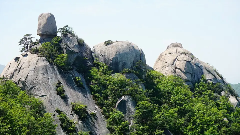
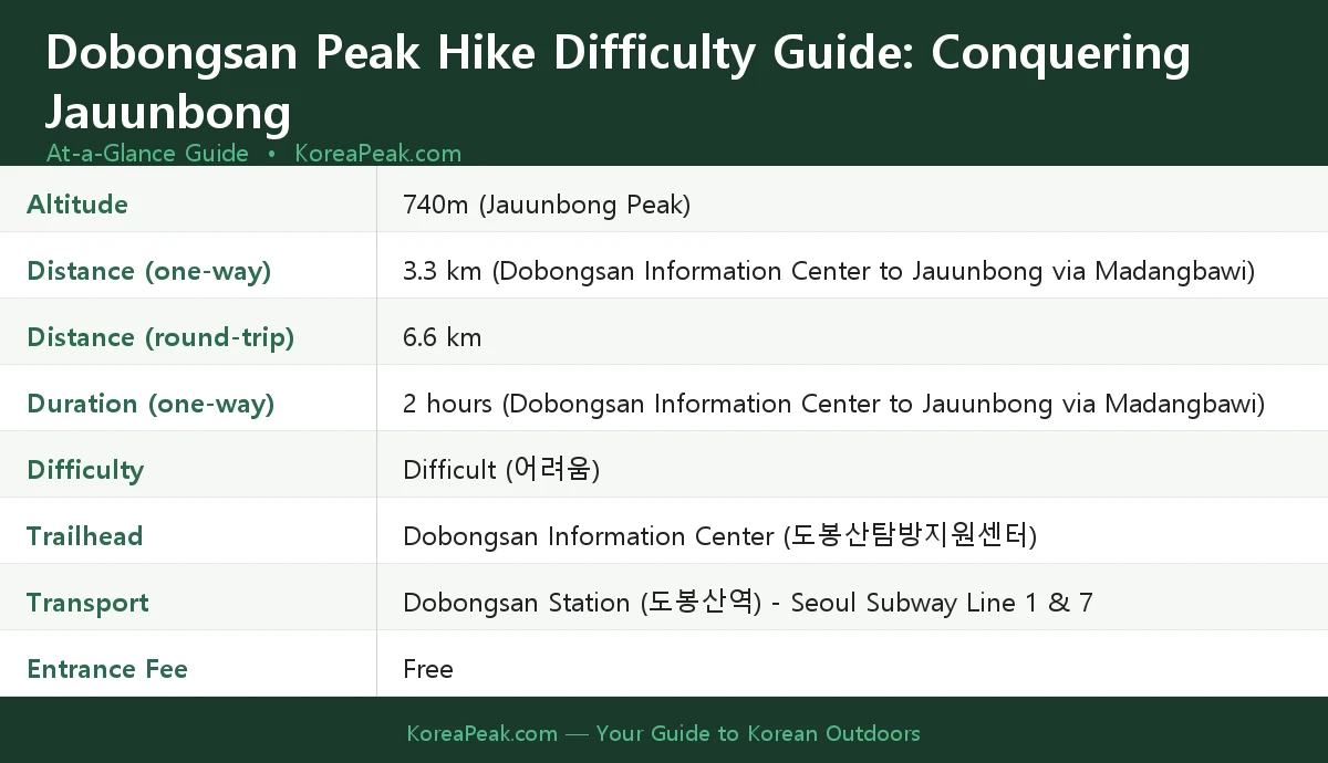
This guide covers a genuine Dobongsan peak hike difficulty guide. Dobongsan’s highest peak is Jauunbong (740 m), but it’s restricted to rock climbing and inaccessible to general hikers, and knowing what to expect before you lace up your boots makes all the difference. Here’s everything you need to plan a safe, enjoyable ascent.
Contents
Getting to the Trailhead
One of the best things about Dobongsan is how easy it’s to reach from central Seoul — no car required. Take Seoul Subway Line 1 or Line 7 to Dobongsan Station (도봉산역). From there, the Dobongsan Information Center (도봉산탐방지원센터) — your official trailhead — is a short walk away.
A quick but important heads-up for international visitors: Google Maps is notoriously unreliable in South Korea. For navigation, use Naver Map or KakaoMap instead — they’re accurate, free, and have English interfaces. To find the trailhead, copy and paste this into the search bar: 도봉산탐방지원센터. It’ll take you straight there.
Before you head up the mountain, stock up on water and snacks at a convenience store near the station. This isn’t optional advice: there are no shops or food stalls on the trail itself. Once you pass the information center, you’re on your own for supplies.
Trail Guide: The Route to Jauunbong
The most direct route to Jauunbong runs from the Dobongsan Information Center via Madangbawi (마당바위). According to the Official Bukhansan National Park trail information page, this route is 3.3 km one-way (6.6 km round-trip), with an estimated ascent time of 2 hours.
The actual destination for general hikers is the adjacent peak, Sinseondae (726 m). The trail is steep and demanding throughout — this isn’t a casual stroll, and the National Park Service rates it accordingly.
Entrance to the national park is completely free. National park entrance fees in Korea were actually abolished in 2007. (Note: The cultural heritage admission fees for temples within national parks were abolished in May 2023, but entrance to the park itself has been free for much longer).
Trails are open from 04:00 AM year-round, allowing for sunrise hikes. Night hiking after sunset is strictly prohibited for safety reasons.
Understanding the Difficulty
Let’s be honest about what you’re signing up for. The National Park Service officially rates this route as Difficult (어려움) — the highest difficulty tier. The trail features steep ascents and sections that require rock scrambling. This isn’t a beginner hike.
That said, it’s achievable for hikers with a reasonable level of fitness and the right footwear. Here’s what I’d suggest keeping in mind:
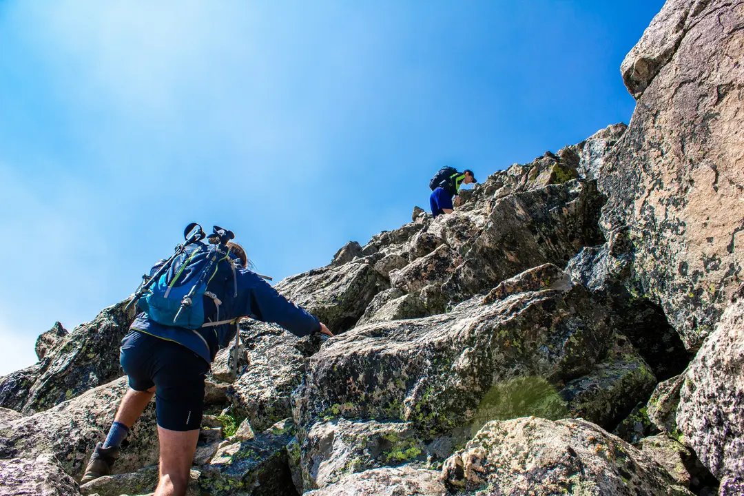
- Wear proper hiking shoes or trail runners with good grip — not sneakers or sandals.
- Trekking poles are helpful, especially on the descent.
- The 2-hour ascent estimate is for a steady, experienced pace, allow more time if you’re not a regular hiker.
- The round-trip distance of 6.6 km may sound short, but the elevation gain and terrain make it significantly more demanding than a flat 6.6 km walk.
If you’re new to hiking or visiting Korea for the first time, I’d suggest treating this as a full-day outing rather than a quick morning activity. Give yourself time to enjoy the views and descend safely.
Practical Tips for Your Hike
A few practical points that’ll make your day on Dobongsan much smoother:
- Water: There are no water fountains available on the trail, so carry sufficient water from the start. Don’t rely on finding water sources along the route.
- Trash: There are no trash cans on the mountain. Every piece of rubbish you bring up, you carry back down. This is standard practice on all Korean mountains, pack a small bag for your waste.
- Snacks: Buy energy snacks at a convenience store near Dobongsan Station before you start. Once past the information center, there are no food options on the trail.
- Layers: Even in summer, temperatures at the summit can be noticeably cooler than at the trailhead. Bring a light jacket.
- Early start: I recommend arriving early, both to beat the crowds (Dobongsan is extremely popular with Seoul locals on weekends) and to give yourself plenty of time before sunset.
- Navigation: Use Naver Map or KakaoMap. Search for 도봉산탐방지원센터 to find the trailhead. Don’t rely on Google Maps.
Seasonal Closures to Know About
This is one of the most important things to check before your visit. Certain sections of Dobongsan, and other Korean national parks, are subject to seasonal closures for fire prevention. These closures typically occur during March to May (Spring) and November to December (Autumn), when dry conditions raise the risk of forest fires.
If you’re planning a visit during these months, check the current closure status before heading out. The main trails to Dobongsan’s summit, including the Madangbawi route to Sinseondae, remain fully open year-round even during fire prevention periods. You don’t need to worry about the main summit routes being blocked. The most reliable place to check is the Official Bukhansan National Park trail information page, or ask at the Dobongsan Information Center when you arrive.
Final Thoughts
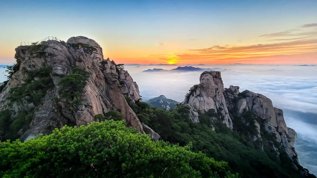
Dobongsan’s Jauunbong peak is one of those hikes that earns its reputation. It’s challenging, it’s steep, and it demands respect, but it’s also remarkably accessible from central Seoul, free of charge to enter, and deeply rewarding for anyone willing to put in the effort. With the right preparation, the right footwear, and enough water in your pack, it’s an experience that’ll stay with you long after you’ve taken the subway back into the city.
Just remember: buy your snacks before the trailhead, carry out all your trash, check for seasonal closures if you’re visiting in spring or late autumn, and use Naver Map, not Google Maps, to navigate. Do those four things, and you’re already ahead of most first-time visitors.
Happy hiking, and take care on those descents!
Have you hiked Dobongsan before, or are you planning your first visit? What’s the one thing you wish you’d known before tackling a challenging Korean mountain trail, drop it in the comments below!