✈This post may contain affiliate links. If you book or buy through these links, I may earn a small commission — at no extra cost to you. I only recommend things I genuinely find useful for your Korea trip.
The summit of Hallasan (한라산), the volcanic peak at the center of Jeju Island, sits behind a reservation system. The two trails that reach Baengnokdam (백록담), the crater lake — Seongpanak (성판악) and Gwaneumsa (관음사) — cap daily visitors, and slots fill weeks in advance during peak season. Come without a booking and the ranger turns you back at the gate.Eorimok (어리목) has no such system. Walk up and hike. The trail climbs 4.7 km to Witseoreum shelter (윗세오름 대피소), a highland rest area at 1,700 m — fully reservation-free, no booking app, no slot to miss.Jeju International Airport (제주국제공항) — start of the car-free route
You give up the crater lake view. You keep the mountain.
Eorimok vs the Summit Trails
Seongpanak is 9.7 km to the summit — a gradual, forest-heavy ascent that takes most hikers four to five hours one way. Gwaneumsa is shorter but technical in sections. Both require advance reservations through the national park system.Eorimok stops at Witseoreum, not Baengnokdam. That distinction takes it entirely outside the reservation requirement. Witseoreum sits where three oreum (오름, Jeju’s volcanic cones) converge on Hallasan’s broad western ridge — hence the name. At 1,700 m it sits well above treeline, with open views west and south. From the shelter, the ridge path continues east toward the Nambyeok cliff face (남벽) or descends southwest via Yeongsil (영실), making a full traverse possible.The honest comparison: Seongpanak and Gwaneumsa get the crater. Eorimok gets the mountain.
Getting There Car-Free: Bus 240
Eorimok sits on the 1100-altitude highway (1100도로, Route 1139), the cross-island road that climbs Hallasan’s western flank. Bus 240 runs this road from Jeju Intercity Bus Terminal (제주시외버스터미널) in Jeju City and stops directly at the Eorimok trailhead entrance.From Jeju International Airport (제주국제공항), a local bus connects to the intercity terminal — the intercity bus zone is on the ground floor of the arrivals building. At the terminal, take bus 240 toward the 1100-altitude road. Departures run roughly once an hour; confirm that day’s schedule at the terminal information desk or via the Jeju public transit app before you go. The ride climbs steadily through the island’s midlands into the volcanic highland.Early departure for Eorimok — last-entry cutoffs reward an early start
Leave early. Last entry to the Eorimok trailhead is enforced and shifts by month — the summer cutoff comes earlier in the afternoon than most visitors expect. Check the current time on the Hallasan National Park website before you commit to a departure.The return is the same bus, same stop. Note the last bus departure before you start up.
Trail Walkthrough: 4.7 km to Witseoreum
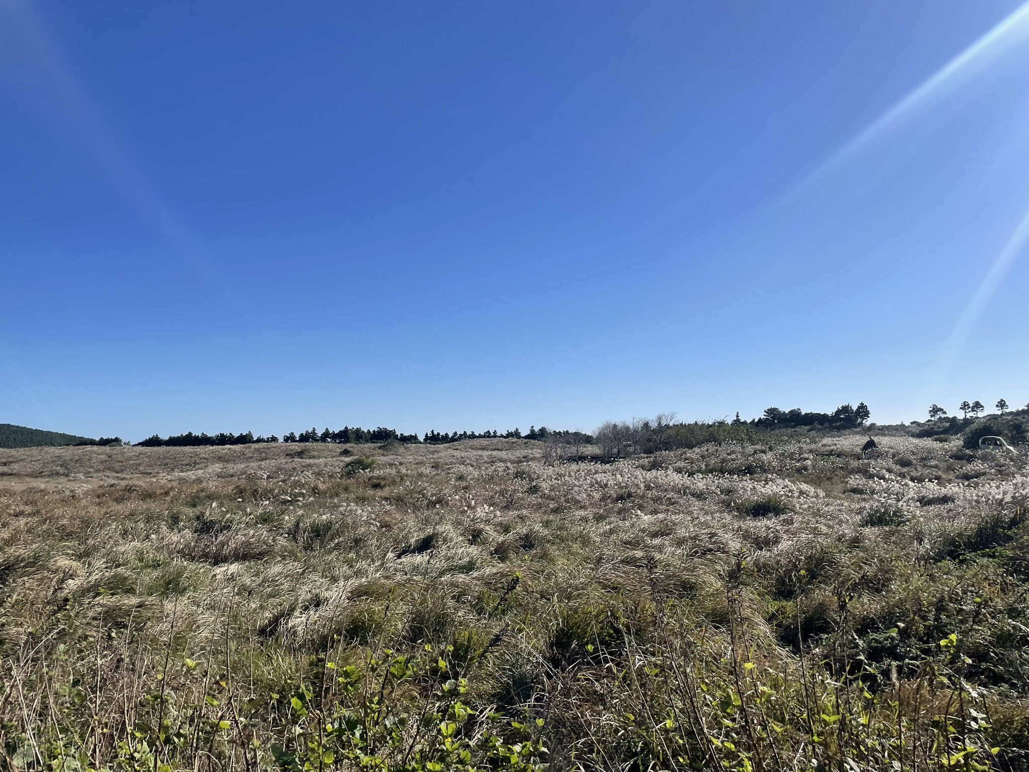
The Eorimok trail (어리목 탐방로) runs 4.7 km from the trailhead to Witseoreum shelter. Well-marked throughout, with stone steps and packed-earth path alternating depending on grade.The lower section passes through dense highland forest. Trees arch over a narrow reddish dirt path, trunks moss-covered, the canopy thick enough to hold humidity even on clear days. Quiet in here.Above the forest the trail opens onto the moorland plateau. The grade eases. Silver grass (억새, eok-sae) spreads in wide arching drifts across the ground, feathery seedheads catching light. The path becomes broad and unobstructed.Witseoreum shelter (윗세오름 대피소) marks the top of the Eorimok climb. A staffed structure with posted trail information — confirm what facilities are available on the day before depending on them.
What You’ll See
The upper plateau is the case for hiking Eorimok. Above treeline, the terrain opens in every direction: silver grass running to a conifer belt on the horizon, the ridge line of Hallasan above.Hallasan’s upper moorland — eok-sae (억새) at full autumn plume
In autumn the eok-sae hits full plume. The whole plateau turns silver-white, moving as one in the wind. It looks nothing like the closed-canopy forest 500 m below.The oreum are a constant visual feature — rounded volcanic cones, each forested on top, rising from the grassland floor. From the upper trail you can pick out several at once.The same highland oreum terrain continues along the 1100-altitude highway below. Narrow rail tracks — part of an eco-tourism installation on the plateau — thread through the grassland between the volcanic cones.On a clear day, the southern views from Witseoreum stretch across the lowlands toward the coast.
Winter: Snow, Crampons, and the Snow Flower Bus
Eorimok in winter is a different trail. Snow accumulates on the moorland from December through February. The silver grass disappears. The lower forest becomes an ice corridor through bare branches.Crampons are required when snow is present — rangers check at the trailhead gate. This is a hard rule, not a suggestion. Light microspikes may handle the lower forested section; the open plateau above treeline can be harder-packed and windswept. Bring appropriate footwear or confirm rental availability locally before your trip.In heavy snow periods, the Jeju provincial government runs the Snow Flower Bus (눈꽃버스), a dedicated seasonal service from Jeju City to Eorimok. It operates on specific dates during peak snow season, and the schedule varies year to year — search 눈꽃버스 or check the Jeju Tourism Organization website for the current season’s announcement.
Practical Tips
Cutoff times. Last entry shifts by month. Summer afternoons close earlier than you’d expect. Check the Hallasan National Park website before you fix your bus departure.Water. No reliable source above the trailhead area. Bring at least 1.5 L per person.Layers. The open plateau above treeline runs cold and windy even when Jeju City is warm. A wind shell is the minimum; add a midlayer for autumn or spring.Bus 240 timing. Confirm departure and return schedules at the terminal the morning of your visit. Schedules adjust seasonally and can differ from published listings.The 1100고지 wetland. The bus route through Route 1139 passes the 1100고지 (一千一百高地), a Ramsar-designated highland wetland sitting in the plateau between the volcanic ridges. It’s a natural add-on if you have time before or after the hike — check local bus stops and schedules for access.Traverse option. A one-way hike from Eorimok to Yeongsil (영실) via the Witseoreum ridge is possible if transport is arranged at the far end. Without a second bus pickup, return on the same trail.If you’re weighing which Hallasan route fits your trip, the car-free Hallasan overview covers the access picture across all trailheads. The Yeongsil trail is shorter and more family-friendly — worth comparing if you’re hiking with mixed experience levels.Hiked Eorimok? Drop your conditions and timing in the comments — crampon and snow reports are especially useful for anyone planning a January or February visit.