Seoul has a mountain at its center that most visitors never set foot on. Not because it’s remote or difficult — but because Bugaksan (북악산, also known as Baegaksan/백악산) was sealed off as a military reservation for decades. The trail only reopened to the public in 2006, and the rules haven’t changed since: stay on the designated path, don’t photograph military installations, and carry your trash out. What you get in return is one of the most historically loaded walks in the city — a hike along the Hanyangdoseong (한양도성), Seoul’s 600-year-old granite fortress wall, with the city spread out below on both sides.
The route from the Malbawi trailhead to Changuimun (창의문) traces the northern arc of the wall, crossing the 342m summit of Baegaksan, passing through Sukjeongmun (숙정문), and following stone crenellations across a ridgeline that looks — honestly — like a smaller, greener Great Wall of Korea. At an easy pace, the whole walk takes a couple of hours.
Finding the Trailhead: Start Near SKKU
The Malbawi trailhead sits at the edge of Seongbuk-dong (성북동), one of Seoul’s quieter upper-residential districts. The most useful landmark for navigation is the side entrance of SKKU — Sungkyunkwan University (성균관대학교), Korea’s oldest university, founded in 1398. The entrance marker is a dark granite monolith with a gold SKKU crest and university name, a brown wooden fence gate running alongside. From here, the Malbawi Visitor Center (말바위 안내소) is a short uphill walk — this is where hikers register before stepping onto the designated path.
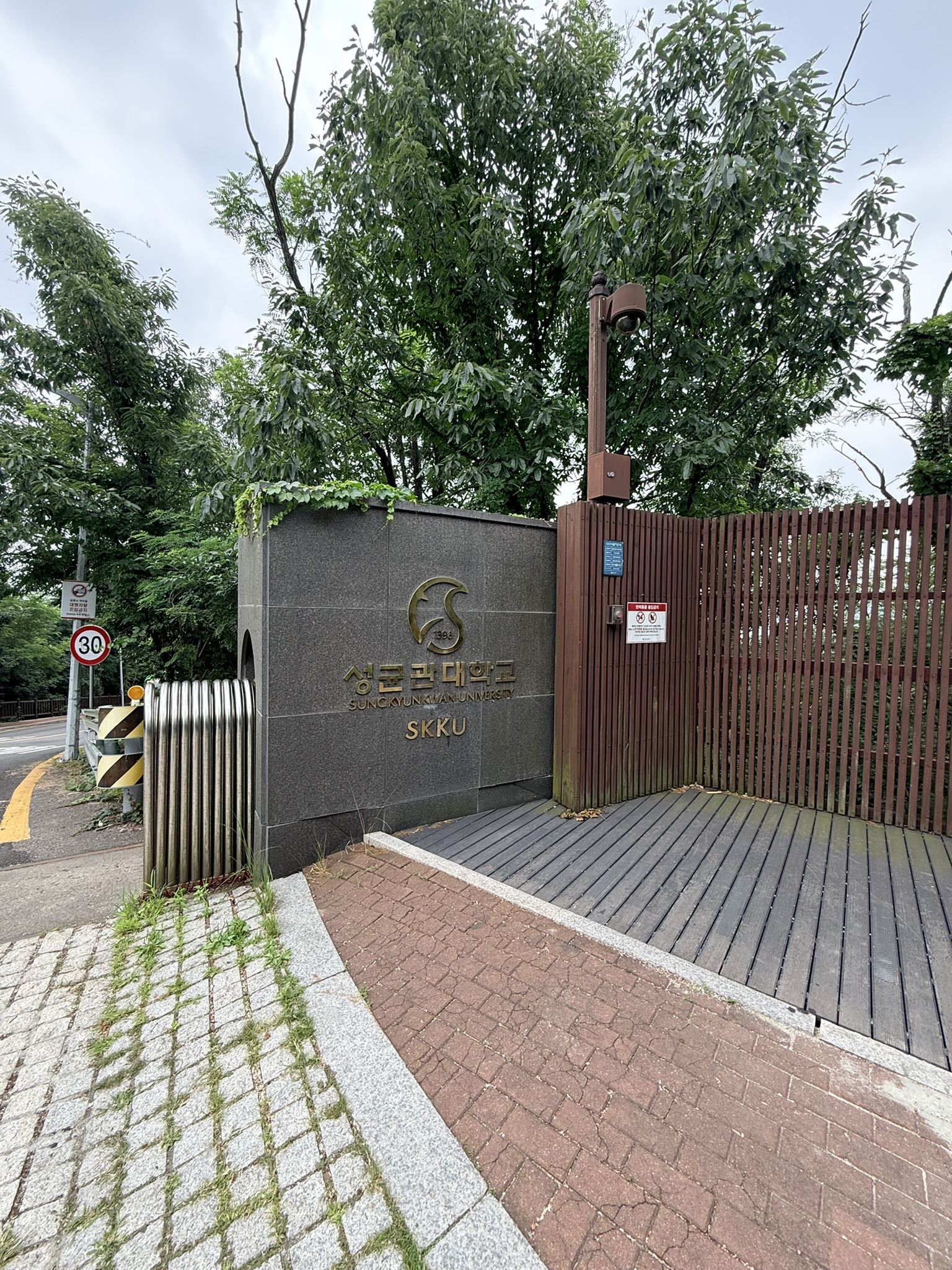
There’s no large trail sign at street level in this direction — the SKKU gate is the clearest physical anchor. Head uphill past it and the visitor center appears within minutes.
Waryong Pavilion: First Stop on the Climb
Before the trail climbs in earnest, a traditional wooden pavilion appears on the left. Waryong Pavilion (와룡정, 臥龍亭 — literally “reclining dragon pavilion”) is a full open-air structure: gray clay tile roof, exposed log beams, carved wooden railings in geometric lattice patterns, stone steps leading up to a raised wooden floor. A brushwork plaque inside the eaves reads 와룡정 in bold black characters. Through the trees to the left, a sliver of city skyline is visible — a quiet preview of the views to come.
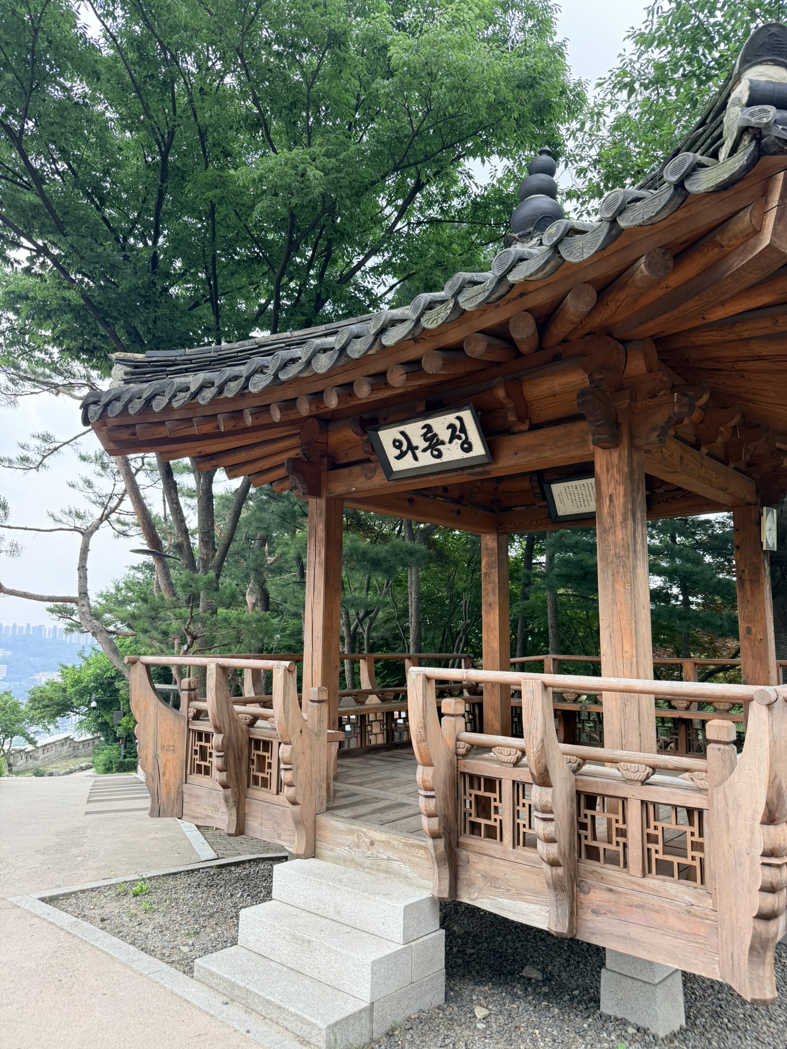
The shade is real and the wooden benches inside work. On a humid summer climb, this counts. It’s a genuine rest stop, not decorative.
The Wall Itself
The first full sight of the Hanyangdoseong stops most hikers. The granite blocks are enormous — cut and fitted in tight courses with almost no visible mortar, rising well above head height, and running straight ahead until they curve out of sight. The scale isn’t obvious from photos: standing next to the wall makes clear that these stones were quarried, moved, and assembled by hand across a mountain more than six centuries ago.
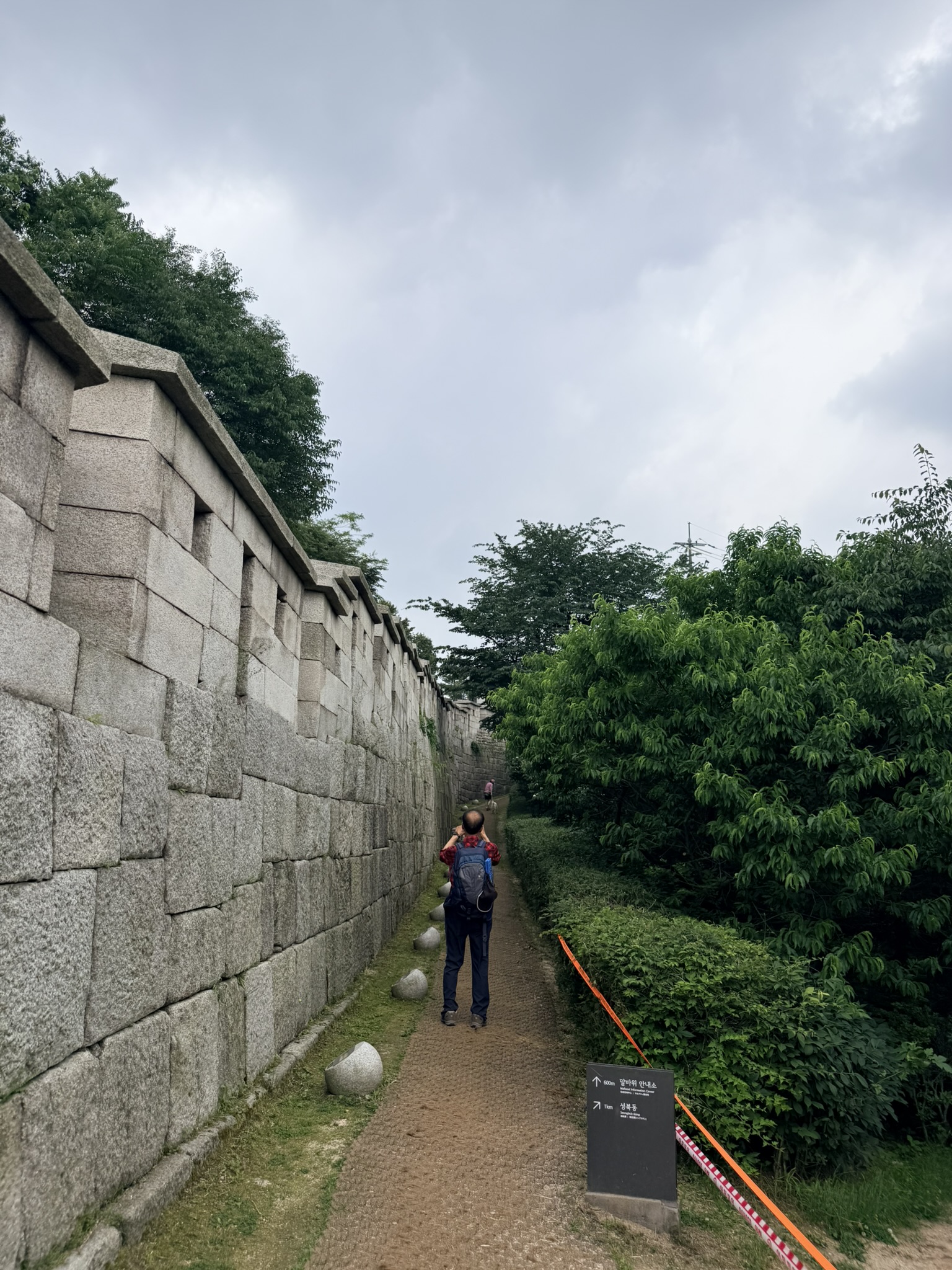
A dark directional signboard in the photo marks the way: 말바위 안내소 (Malbawi Visitor Center) pointing back, 성북동 (Seongbuk-dong) pointing forward. The path runs along the inner face of the wall — packed earth and gravel, wide enough for two people abreast. Wall to the left, shrubs and trees to the right. Orange barrier tape marks the edge of the designated zone.
First Views: Seongbuk-dong From Above
Gain a little elevation and the hill opens up eastward. The neighborhood below is Seongbuk-dong — private homes and low-rise villas packed tightly up a hillside, surrounded by forest. Heavy cloud was pushing in when this was taken, which sharpened the contrast between the green canopy and pale building facades. Apartment towers mark the distant horizon, a reminder that the density of Seoul is never far, even when you’re standing among pines.
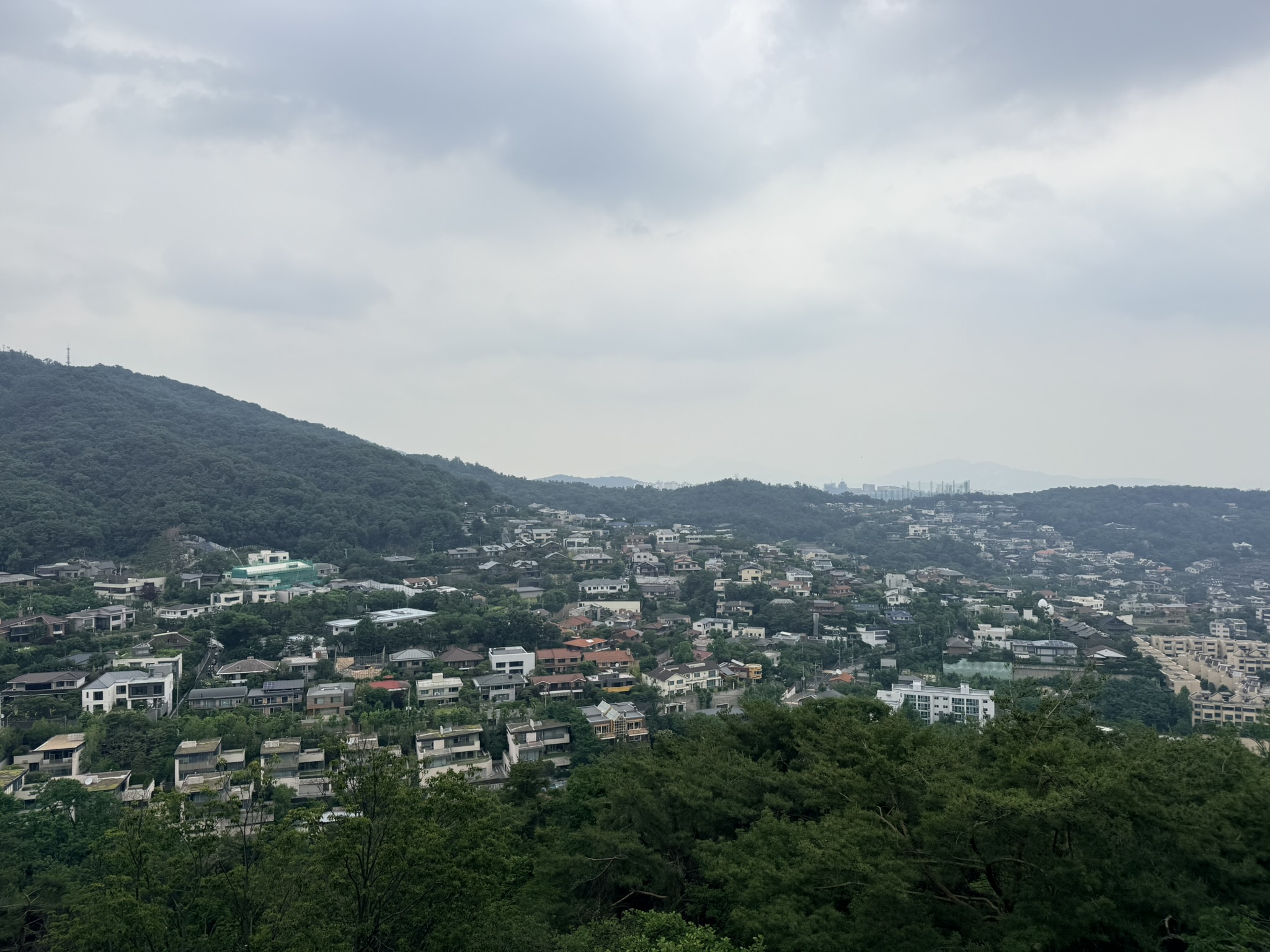
This isn’t the dramatic granite Seoul that most hiking photos show. It’s the lived-in side of the city — flat rooftops, sloped tile, terraced gardens, all stepping up a hillside that residents park cars on. The view puts the trail’s location in context: you’re inside the city, not above it.
The Gnarled Pine
There’s one image from the Bugaksan wall that every hiker takes. A Korean pine growing alongside the path has sent its main trunk at a sharp diagonal, with thick dark branches reaching out horizontally across the stone-paved walkway like a gate you pass under. The bark is deeply furrowed, nearly black. The crown fans out in green above. To the right, the wall’s crenellated parapet runs ahead into the distance, ridgelines visible beyond.
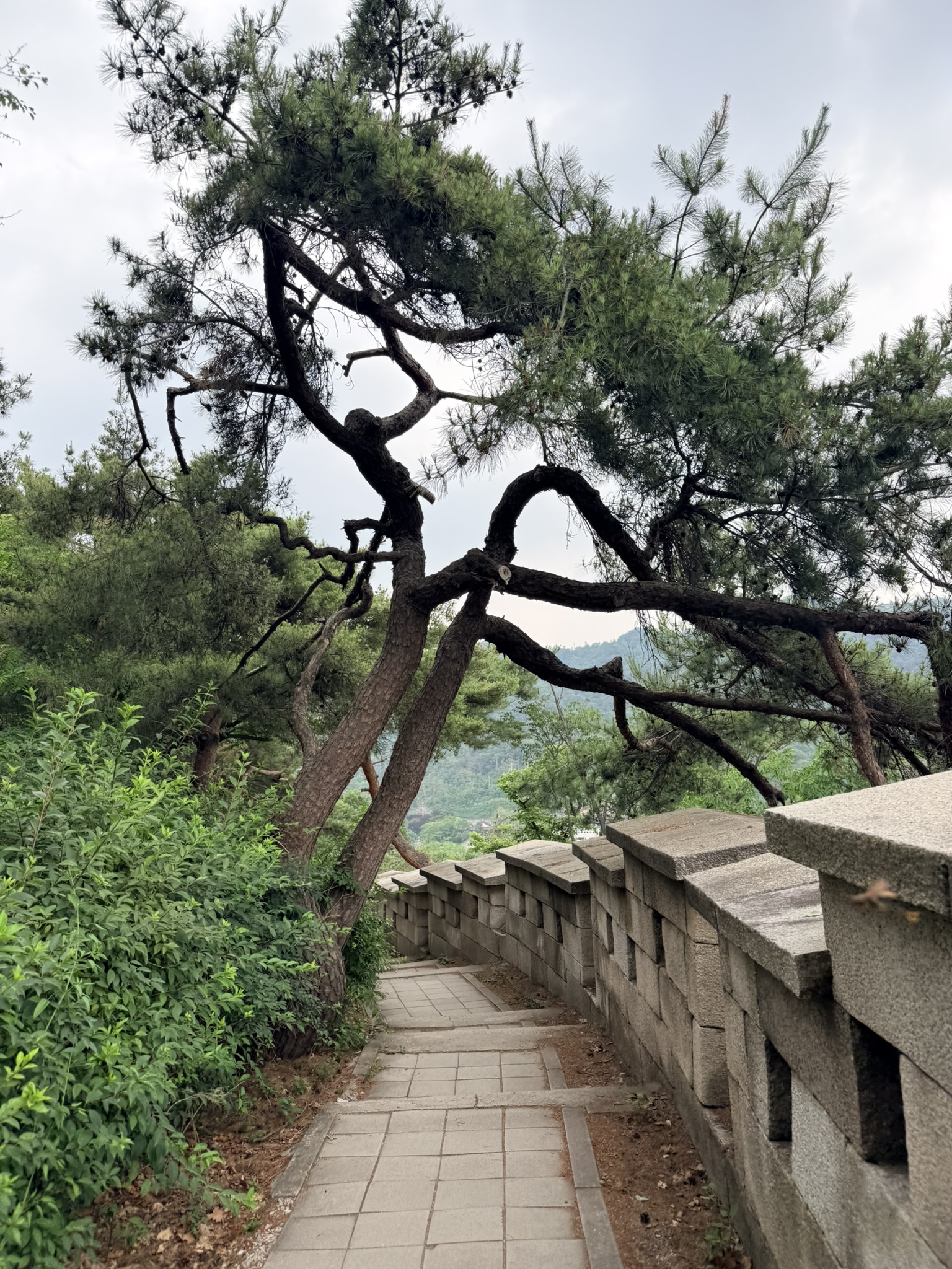
Pines on Korean mountain walls find a crack in the granite and grow for centuries. This one has developed its own architectural logic — it belongs to the trail as much as the stone does.
The Trail Map and Military Rules
At the Malbawi Visitor Center, an official trail board shows the complete Bugaksan route (북악산탐방로 / Bugaksan Trail). The map runs from right to left: starting at the red-highlighted Malbawi Visitor Center (marked 0km), past Sukjeongmun at 300m, up to Baegakmaru (the summit area), continuing through Cheongundae and Goklang, ending at the Changuimun Visitor Center on the far left. A small inset in the top right shows where this section fits within the full 18.6km Hanyangdoseong loop that encircles old Seoul.
Below the route map, a red-bordered warning panel reads in English:
“Mt. Bugak is a military reservation. Stay on the designated trail. Photography of the military base and facility (equipment) is prohibited. Any violation of the above will be prosecuted in accordance with the Protection of Military Installations Act.”
Five prohibition icons follow: no photography of facilities, no weapons, no alcohol, no smoking, no pets.
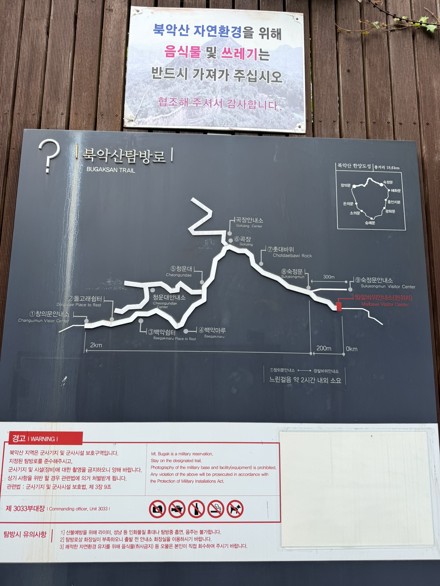
The restriction matters. The trail passes through an active military zone and there are installations visible from the path. Pointing a camera at them — rather than at the wall or the views — is the line. Most hikers never come close to the boundary, but knowing it exists prevents confusion if you spot uniformed personnel or fenced-off areas on the hillside.
Sukjeongmun: Seoul’s Forgotten North Gate
Sukjeongmun (숙정문, 肅靖門) is one of the four great gates of the Joseon-era Hanyangdoseong, but far and away the least known of them. While Namdaemun (South Gate) and Dongdaemun (East Gate) anchor busy commercial districts, Sukjeongmun was built facing north into the mountains and was traditionally kept closed for most of the year — opened only during drought rituals. Today it sits on the Bugaksan trail, quiet and unhurried.
The gate reads from the ground up: a rounded granite arch (홍예문, a full semicircular opening) set in a thick stone base, the arch framed by brick on the inner wall. Above the masonry sits the wooden gate pavilion, its eaves painted in green and black dancheong (단청, traditional Korean architectural paintwork), red pillars visible under the roof. Stone stairs climb the right side up to wall level. Pine trees flank both sides.
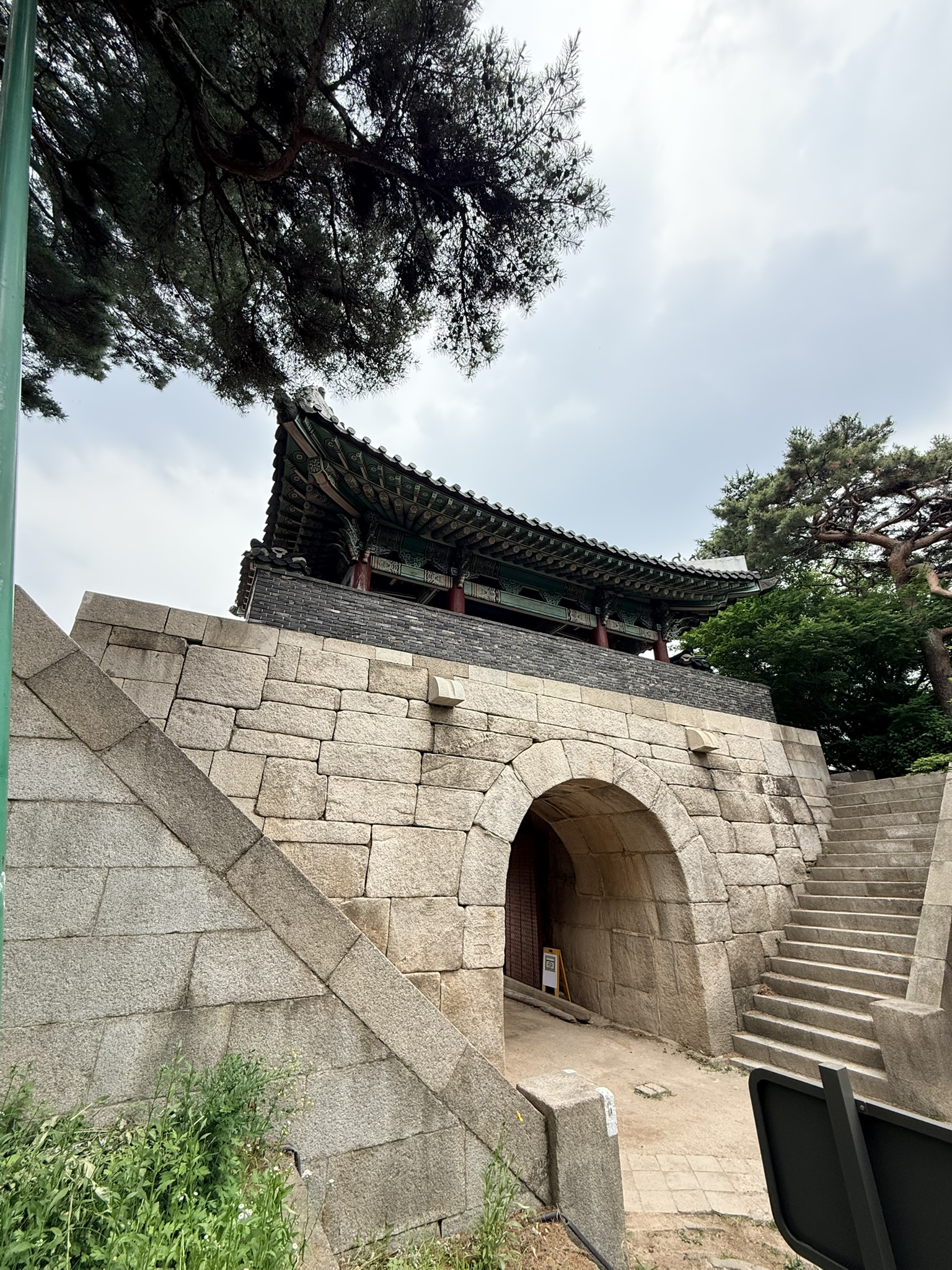
The stone base dates back to 1396, while the wooden pavilion was restored in 1976. Pause here before climbing the stairs — there’s a stamp station nearby, covered in the final section.
The Wall Descends: The Scale of It
Past Sukjeongmun, the wall tips steeply down the far slope of the ridge. The crenellated battlements — yeojang (여장), the rectangular merlons with narrow arrow slits cut through their bases — line up in a receding row down the slope, each one a step lower than the last, until the wall disappears into tree cover below. The Bukhansan (북한산) mountain range fills the background: layered green ridgelines with the granite peaks of Bukhansan visible on the far left horizon.
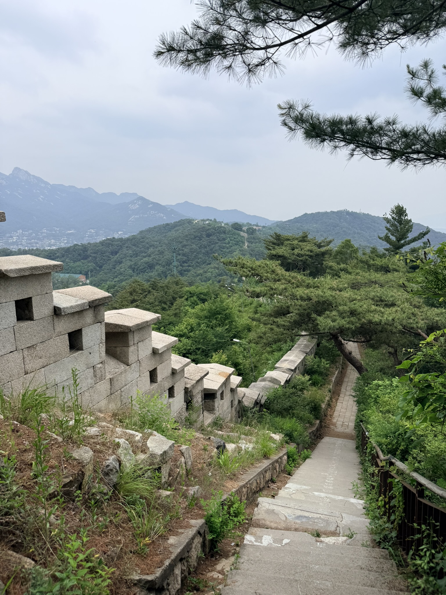
Weeds have pushed up between some stone courses on the outer face — the slow botanical reclaim that signals genuine age. The steps have a metal railing. The descent is steep enough that trekking poles earn their keep here.
Baegaksan Summit: 342m
The summit marker of Baegaksan (백악산, 白岳山) is easy to miss: a small white granite pillar, rounded at the top, with the Chinese-character inscription 白岳山 and 海拔342m carved into the face. It stands on a small gravel clearing, a gray steel railing behind it, gnarled pines leaning out from the green beyond.
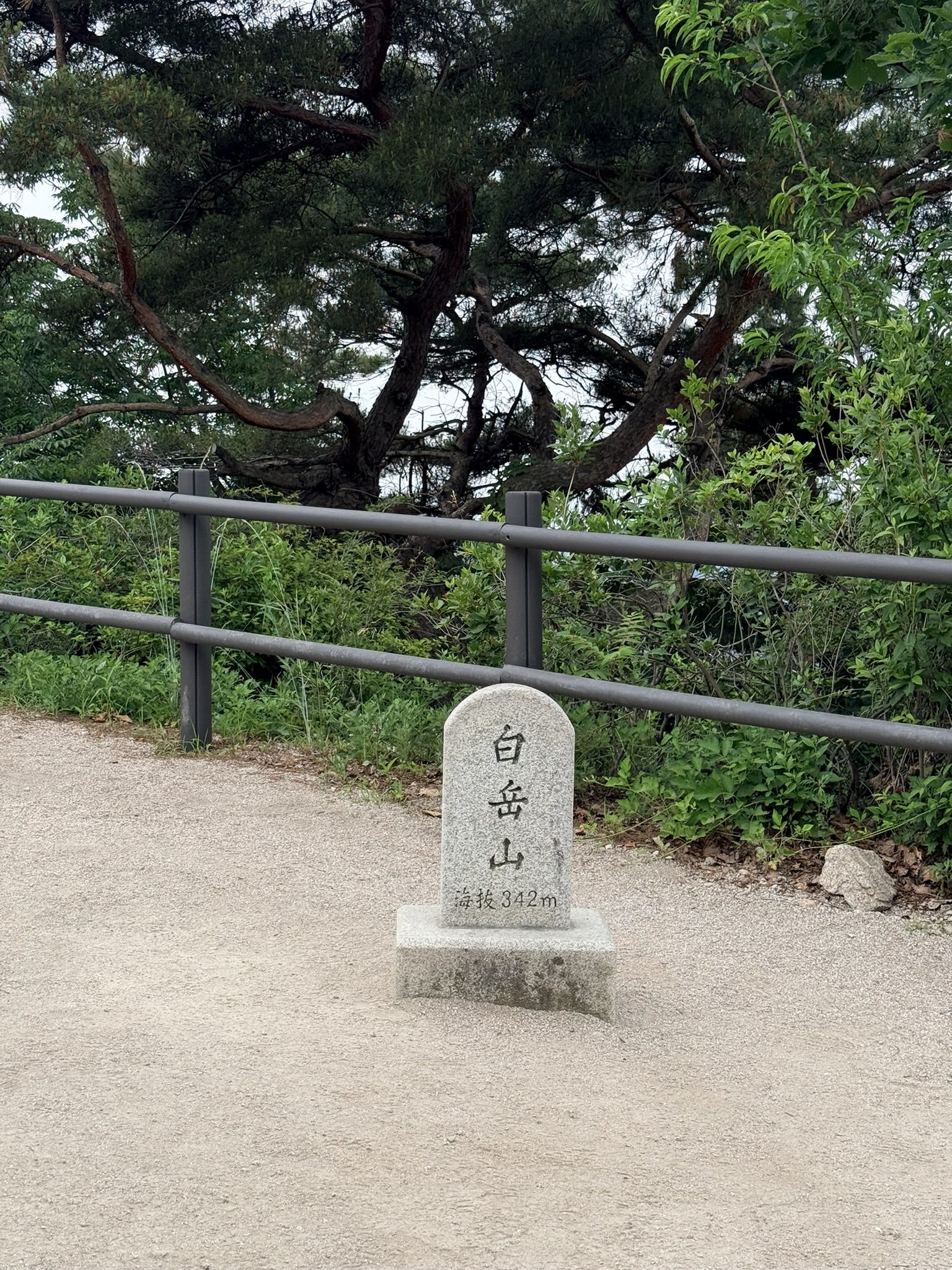
No café. No observatory deck. No commercial infrastructure at all. 342 meters isn’t a demanding elevation, but the gain from the trailhead is sustained and felt. The summit clearing is a brief pause — the open panorama comes a few steps further along the wall.
The View From the Top
The views open fully from the wall section just past the summit marker. Looking northwest, the city descends in layers: dense pine and deciduous canopy in the foreground, then the rooftops of Buam-dong (부암동) spreading across a basin, then the Bukhansan range rising on the right with granite peaks distinct against the sky. Even under a flat overcast — which this was — the layered depth of forest, neighborhood, and mountain reads clearly.
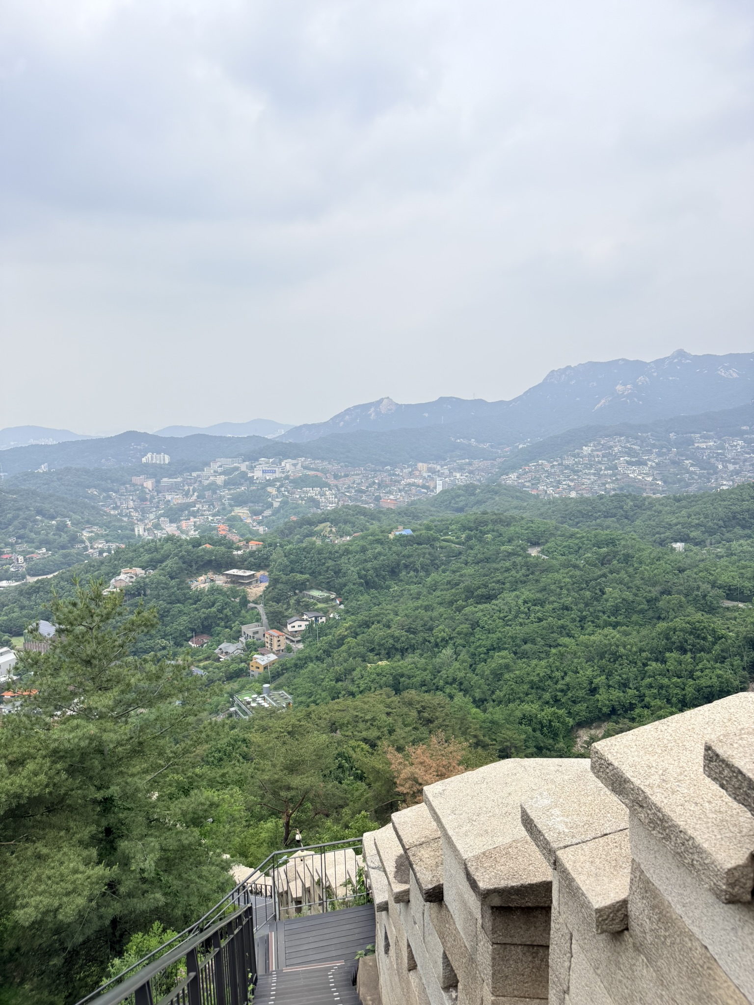
The crenellated wall cuts through the lower-right foreground, anchoring the view in the physical structure you’ve just walked along. A wooden observation deck is visible below the wall. From here, the relationship between mountain, wall, and city is legible all at once.
The Stamp Tour Station at Sukjeongmun
Near the Sukjeongmun visitor area, a small kiosk holds one of the Seoul City Wall Stamp Tour (서울 한양도성 스탬프투어) stations. The wooden stamp box is labeled in four languages: Korean (스탬프 찍는 곳), English (Stamp here), Japanese (スタンプを押す所), and Chinese (请在这里盖图章). The wooden house-shaped box mounted outside the window is marked “숙정문(북대문)” — Sukjeongmun, the North Gate.
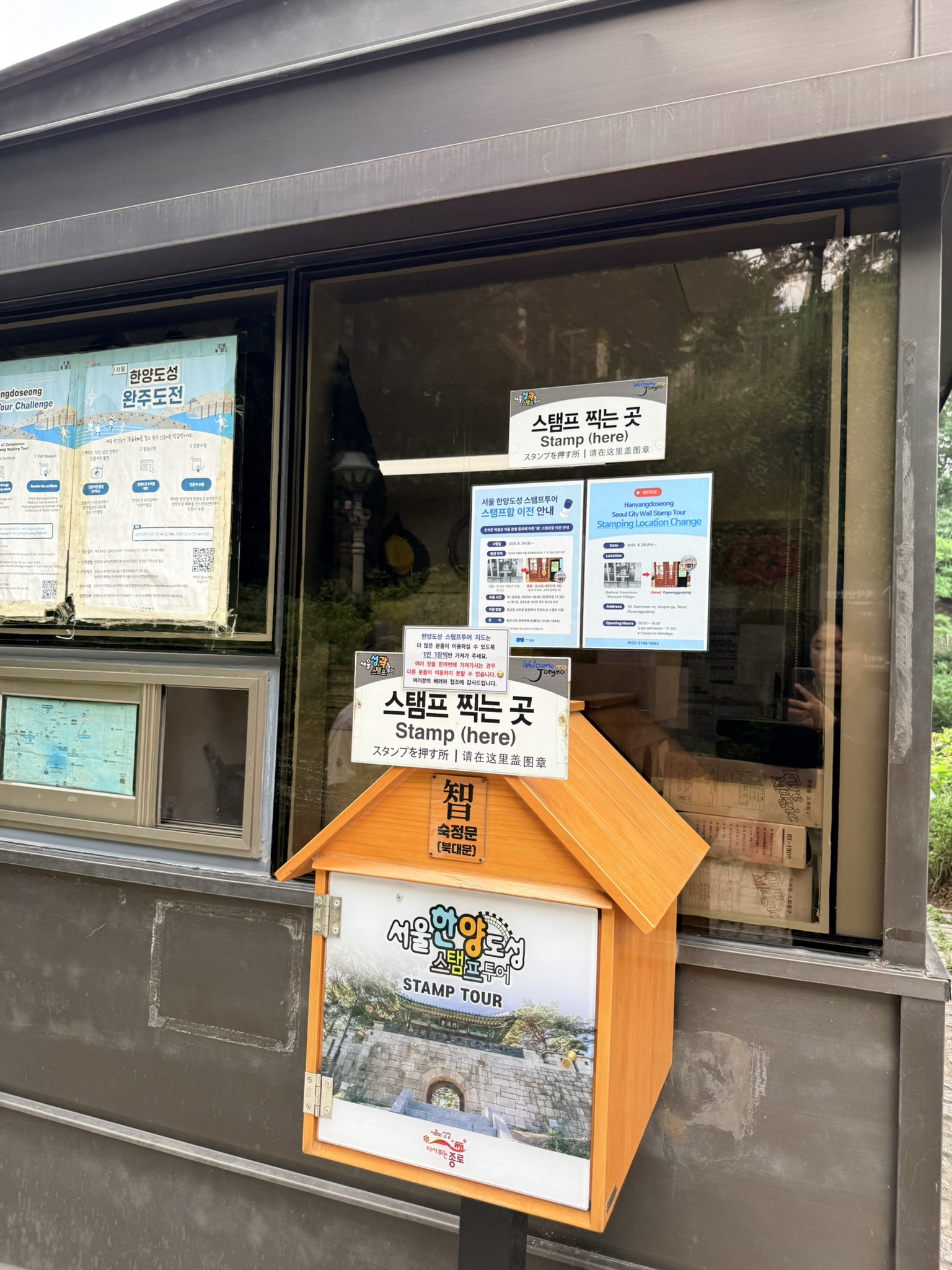
The stamp tour covers the complete Hanyangdoseong circuit. Finishing all stations earns a certificate — the Hanyangdoseong Tour Challenge (한양도성 완주도전) program materials are visible through the window. For foreign visitors, this is one of the most accessible participation activities on any Seoul trail: no Korean required, no advance registration, just find the box and stamp your booklet. Booklets are available at major visitor centers along the route.
From Sukjeongmun, the trail continues west to Changuimun (창의문, also called Jahamun/자하문) — the formal western endpoint of the Bugaksan section. Below Changuimun, the Cheongun-dong (청운동) neighborhood connects easily to Gyeongbokgung Palace (경복궁) and Cheongwadae (청와대), Seoul’s former presidential compound, making for a full historical half-day if you extend the walk downhill.
What Makes This Trail Stand Apart
Most Seoul hikes sit at one of two poles: urban ridgelines close to the subway (Naksan, Inwangsan) or full mountain approaches (Bukhansan, Dobongsan). Bugaksan sits between them — a mountain inside the city, with a 600-year-old wall as the path itself. The military reservation history has kept the ridge quiet and the infrastructure minimal. No cafés at the summit, no stalls at the gates. What’s there is the wall, the pines, the views, and the stone architecture of the Joseon era.
The combination of original historical structures (Sukjeongmun, the Hanyangdoseong wall, Changuimun), a real uphill climb, and expansive north-city views puts this in a different category from Seoul’s more-visited hiking options. The multilingual signage and stamp station mean foreign visitors can navigate the whole route cleanly without Korean. Start early if you can — the north-facing wall catches morning light on the stone well. Bring water, and take your food wrappers with you.
Have you hiked the full Hanyangdoseong loop, or just this Bugaksan section? Drop your questions or route tips in the comments — more Seoul trail coverage is on the way.