
Baengnyeongdo Island Exploring untouched nature is the main draw for visitors willing to make the long journey to Korea’s westernmost inhabited island. Sitting closer to North Korea than to Seoul, Baengnyeongdo sits at the edge of what’s accessible to civilian travelers in this country, and that remoteness is precisely what keeps it quiet. This guide covers what to know before you go, common mistakes to avoid, and how to plan a visit that doesn’t waste the trip.
Contents
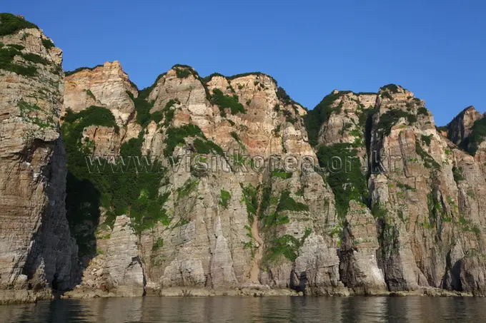
What Makes Baengnyeongdo Different
Most of Korea’s popular islands are well within the country’s domestic tourism circuit. Baengnyeongdo isn’t. Its position near the Northern Limit Line means visitor numbers stay low, infrastructure is limited, and the landscape has been largely left alone. That combination produces the kind of coastal and inland environment that’s increasingly rare on the Korean peninsula.

Because specific trail distances, peak elevations, and seasonal conditions for 2025 and 2026 haven’t been verified through current official sources, treat any figures you find on older travel blogs with caution. Conditions and access rules on islands near military zones can change, and outdated information has a way of causing real problems at the ferry terminal or at a checkpoint.

Getting There
Baengnyeongdo is reached by ferry from Incheon. The crossing is long by Korean standards, and weather in the West Sea can delay or cancel departures without much notice. A few things worth knowing before booking:
The route is currently served by the ‘Korea Pride’ (a 1,600-ton high-speed ferry) and ‘Korea Princess’, both operated by Korea Express Ferry. ‘Korea Pride’ typically departs Incheon at 08:30 AM, taking approximately 3 hours and 45 minutes to 4 hours.
Permits and Military Zones
This is where many first-time visitors to Baengnyeongdo run into trouble. The island sits in a sensitive military area, and certain zones are restricted or require advance registration. The rules aren’t always clearly communicated in English, and they can be updated with little fanfare.
- While foreign nationals do not require a special entry permit to board the ferry, a valid Passport or Alien Registration Card (ARC) is mandatory for ticketing and boarding. Note that photography is strictly prohibited near military facilities and toward the North Korean coastline. Don’t assume that a ferry ticket is all you need to move freely on the island.
- Some coastal and inland areas may be off-limits entirely, or accessible only with a local guide or as part of an organized tour. Verify this before planning any independent hiking.
- Military personnel are present on the island. Follow posted signs and instructions from any uniformed personnel without question. Wandering into a restricted area isn’t a minor inconvenience here.
- Regulations can shift based on inter-Korean relations and military exercises. Check current entry requirements close to your travel date, not months in advance.
Practical Tips on the Island
Remote islands in Korea share a few practical realities that are worth knowing regardless of which one you’re visiting.
- Mobile data coverage may be inconsistent. Download offline maps via Naver Map or KakaoMap before leaving the mainland. Google Maps coverage in this part of Korea is unreliable.
- ATMs may be scarce or limited to certain bank cards. Carry enough cash from Incheon to cover your full stay, including meals, accommodation, and any transport on the island.
- Korea’s Leave No Trace rules apply everywhere, including remote islands. There are no trash cans on most trails. Pack a small bag for your waste and carry it out.
- Bring water. Hydration points along trails aren’t guaranteed, and the island’s small shops may not always be open when you need them.
- Layers matter more than a single heavy jacket. Coastal weather shifts quickly, and wind off the West Sea can make a mild day feel significantly colder.
- If you’re renting a vehicle or bicycle on the island, confirm availability in advance. Don’t count on walk-in rentals being available, particularly outside peak season.
While not as dense as Seoul, major convenience store chains (CU, GS25) are now located in the island’s main residential areas like Baengnyeong-myeon, though they may not operate 24 hours. Local restaurants specializing in ‘Baengnyeongdo Naengmyeon’ (cold buckwheat noodles) are also reliable food sources during daylight hours. Plan meals more carefully than you would on the mainland.
Common Mistakes Visitors Make
A few patterns come up repeatedly among visitors who have a difficult time on remote Korean islands.
- Relying on outdated information. Blog posts and travel guides from previous years may describe ferry routes, trail access, or permit requirements that no longer apply. Always verify through current official channels.
- Underestimating the journey. The ferry crossing to Baengnyeongdo isn’t a short hop. Factor in travel time to Incheon, port check-in time, the crossing itself, and the possibility of weather delays. Visitors who plan a tight itinerary often end up cutting the island visit short or missing the return ferry.
- Ignoring military zone rules. This is the most consequential mistake. Restricted areas exist for real reasons, and the consequences of entering them without authorization are serious. When in doubt, stay on marked paths and ask locally.
- Arriving without Korean-language capability or a translation tool. English signage on Baengnyeongdo is limited. Having Naver Papago or a similar translation app ready on your phone makes a practical difference when reading trail markers, menus, or posted notices.
- Booking accommodation too late. The island has a small number of guesthouses and minbak (family-run lodging). These fill up faster than visitors expect, particularly during Korean school holidays.
- Not checking weather before departure. Ferry cancellations due to weather are common in the West Sea. If your schedule has no flexibility, a weather delay can strand you in Incheon or on the island longer than planned. Build buffer days into the trip.
Before You Finalize Your Plans
Because specific trail data, ferry schedules, permit requirements, and seasonal conditions for Baengnyeongdo couldn’t be verified through current official sources, the most responsible advice here’s straightforward: confirm every logistical detail through current official channels before booking anything.
The island rewards visitors who plan carefully and travel with flexibility. The remoteness that makes Baengnyeongdo’s natural environment worth visiting is the same quality that makes poor planning costly. A trip that accounts for weather delays, permit requirements, and limited on-island services tends to go well. One that doesn’t tends to fall apart at the ferry terminal.
Check Naver Map for current trail and transport details closer to your travel date, and confirm entry requirements for foreign nationals directly with the relevant Korean authorities before departure.
* Cover image source: ⓒ한국관광공사 포토코리아-전태헌