For a hike that combines mountain scenery with genuine Korean history, the Geumjeongsan hiking trail fortress route in Busan is one of the most rewarding walks you’ll find on the peninsula. Stretching along the walls of Korea’s largest mountain fortress, this point-to-point trail delivers panoramic views of Busan’s coastline and cityscape — all for free.
Contents
Quick Facts
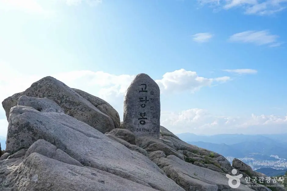
| Peak Altitude | Godangbong (고당봉) 801.5m |
|---|---|
| Distance | Approximately 7.0 km (from Dongmun to Beomeosa via Godangbong) |
| Duration | 3 hours 30 minutes. |
| Difficulty | Moderate |
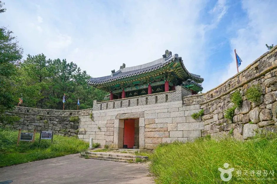
| Trailhead | Geumjeongsanseong Dongmun (금정산성 동문) |
| Transport | To Dongmun: Oncheonjang Station (온천장역) Exit 3, then cross the connected skybridge to the ‘Oncheonjang Station’ bus stop (in front of SK Hub Sky) to take Bus 203. From Bukmun: Descend approximately 2.5km (45 mins) to the ‘Beomeosa Entrance’ bus stop, and take Bus 90 to Beomeosa Station (범어사역). |
| Entrance Fee | Free |
| Operating Hours | Sunrise to sunset (no night hiking) |
| Seasonal Closures | Spring: February 15 – May 15 / Autumn: November 1 – December 15 |
Why Geumjeongsan Fortress?
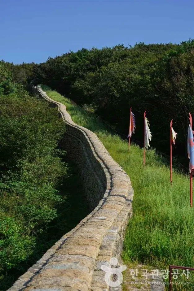
Geumjeongsanseong (금정산성) isn’t just a hiking backdrop — it’s a piece of living Korean history. Designated as Historic Site No. 215, the fortress walls stretch approximately 17 kilometres across the ridgeline, making it the largest mountain fortress in Korea. Walking along those ancient stone walls with the city of Busan spread out below you is a special experience that you won’t find anywhere else in the country.
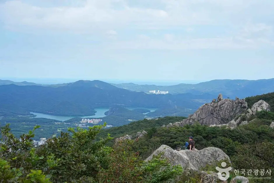
The highest point on the mountain is Godangbong (고당봉), standing at 801.5 metres above sea level. From the summit and along the ridge, hikers are treated to panoramic views of Busan city, the coastline, and the surrounding mountainous landscape — a reminder of just how dramatically this city sits between the sea and the hills. For more background on the fortress and its cultural significance, check out the official Visit Korea page for Geumjeongsanseong Fortress.
Getting There by Public Transport
Before anything else — a heads-up for international visitors: Google Maps doesn’t work reliably in Korea for public transport or walking directions. Use Naver Map or KakaoMap instead. To search for the trailhead, copy and paste this text directly into either app:
금정산성 동문 (Geumjeongsanseong Dongmun — East Gate)
This is a point-to-point trail, so you’ll start at the East Gate and finish at the North Gate (Bukmun, 북문). Here’s how to get to each end:
Getting to the Trailhead (Dongmun — East Gate)
- Take the metro to Oncheonjang Station (온천장역) and use Exit 1.
- From there, board Bus 203 and ride it to the Geumjeongsanseong Dongmun stop.
- Always verify current bus schedules and stops on Naver Map before your trip, as timetables can change.
Getting Back from the Endpoint (Bukmun. North Gate)
- After finishing the hike at Bukmun, descend toward Beomeosa Temple (범어사).
- From Beomeosa, take Bus 90 to Beomeosa Station (범어사역) to connect back to the metro network.
- Again, double-check this route on Naver Map before you go, bus numbers and stops are confirmed as of the time of writing, but it’s always smart to verify.
Trail Guide: Dongmun to Bukmun
The main hiking route on the Geumjeongsan hiking trail fortress follows a point-to-point path from Geumjeongsanseong Dongmun (East Gate) to Bukmun (North Gate), passing over Godangbong, the mountain’s highest peak at 801.5 metres. The total one-way distance is 8.5 kilometres, and most hikers complete it in around 4 hours and 30 minutes. The trail is rated moderate in difficulty, which means it’s accessible to reasonably fit hikers without technical climbing experience, but it’s not a casual stroll either, plan accordingly.
Along the way, you’ll be hiking in the company of the ancient fortress walls themselves. The walls of Geumjeongsanseong stretch approximately 17 kilometres in total, and this route traces a significant portion of that historic structure. The ridge offers panoramic views of Busan city, the coastline, and the surrounding mountains, on a clear day, the scenery is spectacular.
The trail concludes near Bukmun (North Gate), from where you can make your way down toward Beomeosa Temple (범어사), one of Korea’s most celebrated Buddhist temples, before catching the bus back to the metro.
A few things to keep in mind as you plan your day:
- This is a one-way, point-to-point route, you’ll need to arrange transport at both ends.
- Hiking is only permitted between sunrise and sunset. No night hiking is allowed.
- The trail is subject to seasonal closures, typically during March. May and November. December, for fire prevention. Always check current closure status before heading out.
- Entrance to the trail and fortress area is completely free.
Practical Tips for Visitors
What I pack for the fortress loop
This is one of the most important things to know about hiking in Korea: there are no shops, vending machines, or restaurants on the trail. Once you leave the trailhead, you’re on your own for food and water. I recommend stopping at a convenience store near Oncheonjang Station before boarding the bus. Pick up enough water for the full 8.5 km, plus some snacks. Korean convenience stores are excellent for trail food: kimbap, energy bars, banana milk, and triangle rice balls are all solid choices.
Pack It In, Pack It Out
There are no trash cans anywhere on the trail. This is standard across Korean mountains, hikers are expected to carry all their waste back down with them. Bring a small bag to collect your rubbish and dispose of it at the trailhead or back in the city. It’s a simple rule that keeps these mountains beautiful, and locals take it seriously.
Navigation in Korea
As mentioned above, Google Maps is unreliable for navigation in Korea. Download Naver Map or KakaoMap on your phone before your trip. Both apps have English-language interfaces and provide accurate public transport directions. To find the trailhead, search for: 금정산성 동문
Seasonal Closures. Check Before You Go
During fire prevention periods, some ridge sections may be restricted, but main trails like the Dongmun-Bukmun route often remain open. Always check the KNPS website for real-time trail status. These dates can shift slightly year to year, so always check the current status before making the trip. A quick search on Naver Map or the official Visit Korea website will give you up-to-date information.
What to Wear and Bring
- Footwear: Proper hiking shoes or trail runners, the terrain is uneven in places.
- Layers: Mountain temperatures can be significantly cooler than the city, especially near the summit. Bring a light jacket even in warmer months.
- Water: Carry more than you think you’ll need, there are no water fountains on the trail.
- Sun protection: Hat, sunscreen, and sunglasses for exposed ridge sections.
- Snacks: Enough fuel for a 4.5-hour hike.
- Trash bag: A small bag to carry your waste back down.
Timing Your Hike
I’d suggest starting as early as possible, especially in summer, when midday heat on an exposed ridge can be punishing. An early start also means you’re more likely to have the fortress walls to yourself before the weekend crowds arrive. Remember, hiking must be completed before sunset, so factor in your 4.5-hour trail time plus the descent to Beomeosa when planning your departure.
Final Thoughts
The Geumjeongsan hiking trail fortress route is one of Busan’s genuine highlights, a hike that earns its views and delivers a history lesson along the way. Walking the ridgeline of Korea’s largest mountain fortress, with the city and coastline stretching out below, is the kind of experience that stays with you long after you’ve come back down. It’s free, it’s accessible by public transport, and it’s unlike anything else in Busan.
Just remember the golden rules: stock up on water and snacks at a convenience store before you start, check for seasonal closures in advance, use Naver Map for navigation, and carry all your trash back down. Do those things, and you’re set for a brilliant day on the mountain.
Have you hiked the Geumjeongsan fortress trail before, and if so, which section of the ancient walls impressed you the most? Drop your experience in the comments below!
* Cover image source: ⓒ한국관광공사 포토코리아-신민선